MESONET TICKER ... MESONET TICKER ... MESONET TICKER ... MESONET TICKER ...
January 13, 2014 January 13, 2014 January 13, 2014 January 13, 2014
80 degrees in mid-January?
http://ticker.mesonet.org/archive/20140113/target.jpg
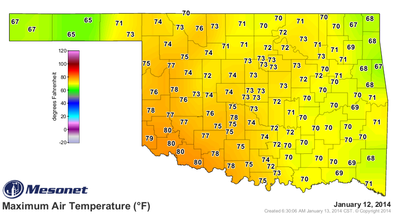
Quite simply put, yesterday was one of the warmest first-12-days-of-January on
record (not sure if I needed those dashes, but I often over-dash anyway). Highs
from the Oklahoma Mesonet reached as much as 80 degrees across southwestern
Oklahoma, with 70s nearly statewide. Then compare that to the historical record
highs for January 12.
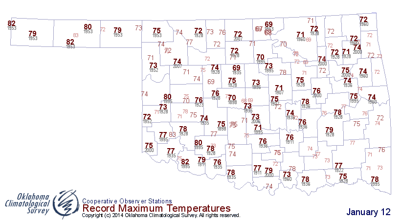
http://ticker.mesonet.org/archive/20140113/jan12-highs.png
http://ticker.mesonet.org/archive/20140113/jan12-record-highs.png
So we undoubtedly saw plenty of records broken, or at least got close. Oklahoma
City broke its previous record high of 73 degrees (1935) with a new record mark
of 75 degrees. I also saw that the Frederick airport reported a high of 85
degrees. That's a bit of an outlier by several degrees, so I'm not sure if it is
accurate just yet. Even if it turns out to be erroneous, there is still no doubting
that we saw many of the highest temperatures ever recorded historically on
January 12 in Oklahoma, dating back to the late 1800s. Here are the top highest
readings on record for January 12 (including the Frederick reading). You'll
notice 1995 and 1953 dominate the top marks. Well, at least until yesterday at
least.
-***-
Historical Warmest Maximums (Jan. 12)
85 FREDERICK APT 2014
83 ALTUS DAM 1995
83 GUYMON 1953
82 FREDERICK 1995
82 GOODWELL 1953
82 KENTON 1953
80 ALTUS MESONET 2014
80 GRANDFIELD MESONET 2014
80 HAMMON 1995
80 HOOKER 1953
80 MANGUM MESONET 2014
80 TIPTON MESONET 2014
80 WICHITA MTN WR 1995
-****-
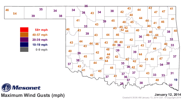
I think those temperatures yesterday were a welcome break from the bone-chilling
winter season we've had thus far, at least for most sane people. Unfortunately,
they also came with a cost. Normally, when you see those types of temperatures
this time of the year, you're going to also see strong southerly winds bringing
that warmer air up from the south. The problem is when you combine that type of
heat with high winds and also low relative humidity, you get extreme fire
danger, and that's exactly what we saw yesterday. Southerly winds gusted to
over 40 mph across much of the state.
http://ticker.mesonet.org/archive/20140113/yesterday.gust.gif
Combine that with relative humidity in the 15-35% range and you had the makings
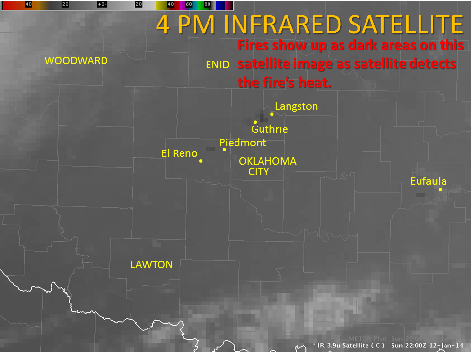
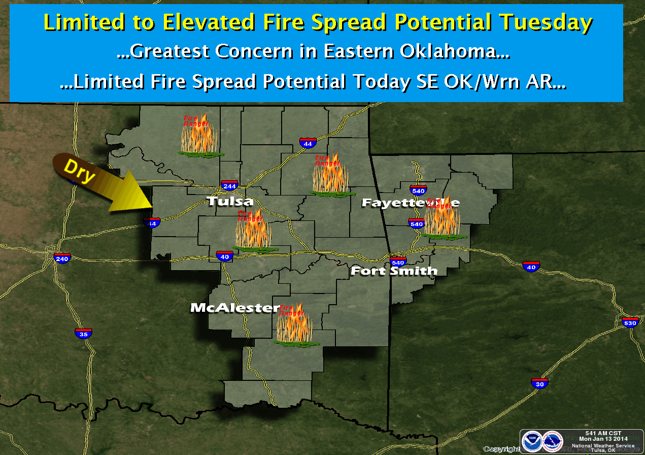
of a wildfire outbreak. Numerous fires did occur across the state, as noted by
our friends at the local NWS offices.
http://ticker.mesonet.org/archive/20140113/wildfires-satellite.png
Our friends at the Oklahoman indicate crews were fighting fires in Oklahoma,
Logan, Canadian, Grady and Lincoln counties.
The good news is our mild weather will continue. RELATIVELY mild, that is ...
we're not going to be back in the 70s, but compared to what we saw a week ago,
it's downright balmy.
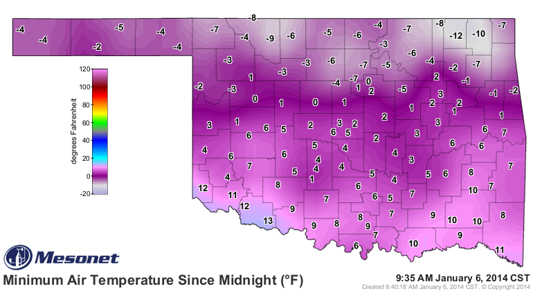
http://ticker.mesonet.org/archive/20140106/todays-lows.png
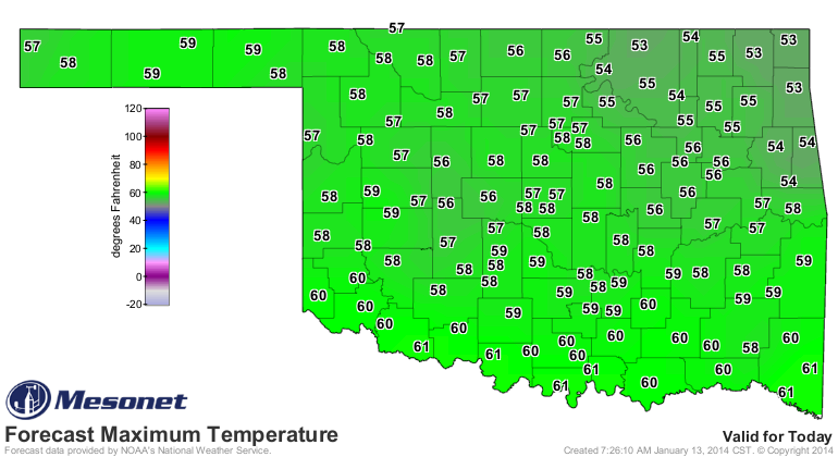
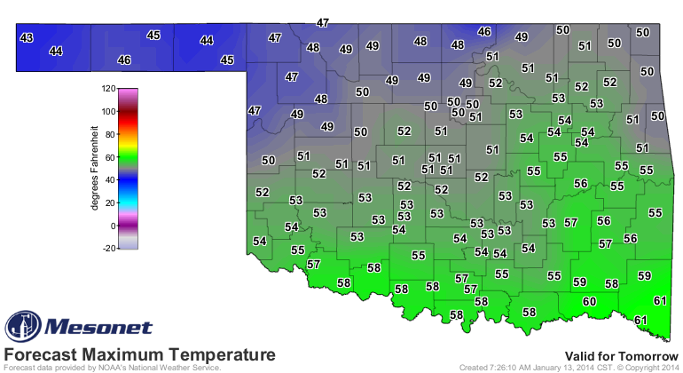
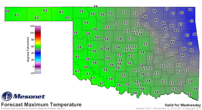
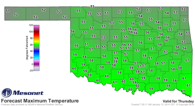
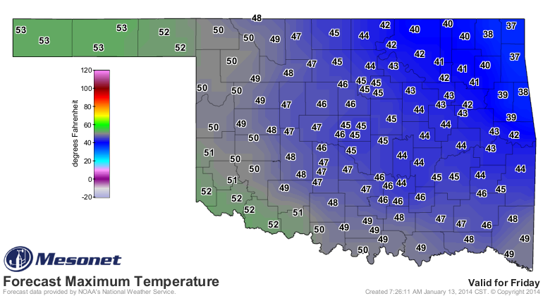
Highs should be seasonable to just-above-seasonable norms in the 50s, with an
occasional jaunt into the 40s or 60s.
http://ticker.mesonet.org/archive/20140113/todays-highs.png
http://ticker.mesonet.org/archive/20140113/tuesday-highs.png
http://ticker.mesonet.org/archive/20140113/wednesday-highs.png
http://ticker.mesonet.org/archive/20140113/thursday-highs.png
http://ticker.mesonet.org/archive/20140113/friday-highs.png
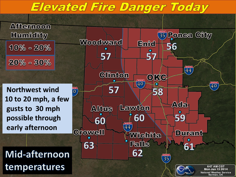
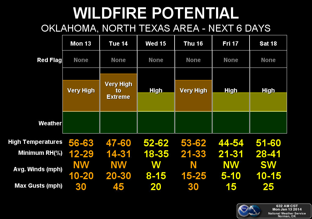
The bad news? No 70s (or 80s) on those maps. The other bad news? Despite the
milder weather, we will still see high fire danger thanks to that low humidity
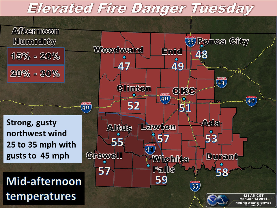
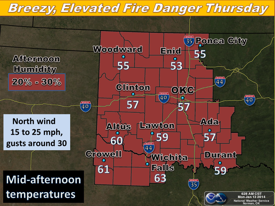
and strong winds. Here's the layout from the local NWS offices.
http://ticker.mesonet.org/archive/20140113/nws-norman1.jpg
http://ticker.mesonet.org/archive/20140113/nws-norman2.jpg
http://ticker.mesonet.org/archive/20140113/nws-norman3.jpg
http://ticker.mesonet.org/archive/20140113/nws-norman4.jpg
http://ticker.mesonet.org/archive/20140113/nws-tulsa.png
We're now just about halfway through climatological winter. Come March 1, it's
springtime!
The good news, part II? No February 29th this year, so no extra delays on
spring. Did I just doom us to the coldest March on record?
Gary McManus
State Climatologist
Oklahoma Climatological Survey
(405) 325-2253
gmcmanus@mesonet.org
==================================================
The OCS/Mesonet Ticker
https://ticker.mesonet.org/
To subscribe or unsubscribe from the Ticker
or for questions about the Ticker or its content
Phone or Email the Ticker Manager at OCS
Phone: 405-325-2253 Email: ticker@mesonet.org
---------------------------------------------------
-C- Copyright 2024 Oklahoma Climatological Survey
===================================================
|


 Tweet
Tweet