MESONET TICKER ... MESONET TICKER ... MESONET TICKER ... MESONET TICKER ...
December 30, 2015 December 30, 2015 December 30, 2015 December 30, 2015
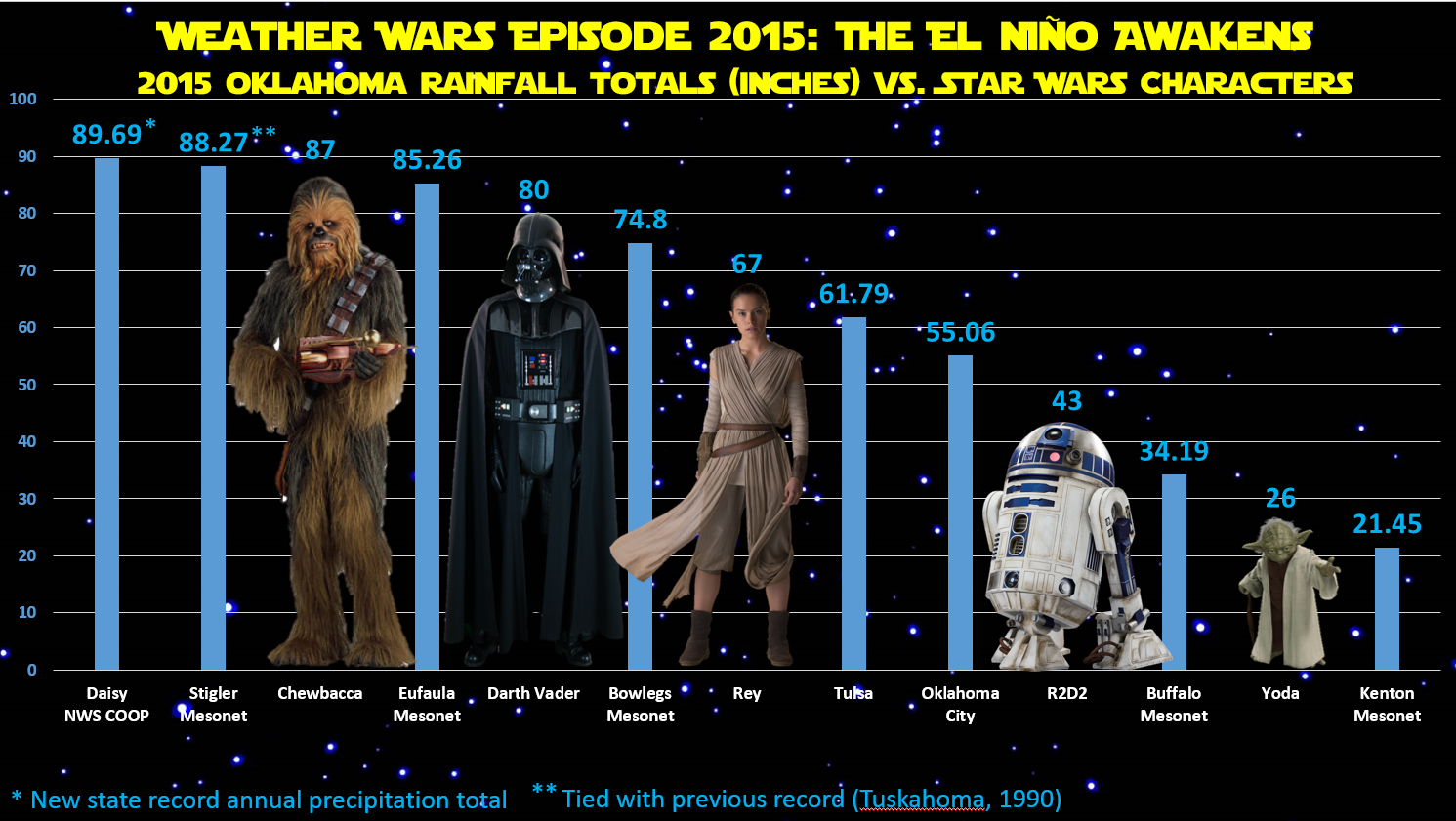
Weather Wars Episode 2015: The El Ni?o Awakens
Oh, I know what you're thinking..."How do the Oklahoma 2015 rainfall totals
compare to my favorite Star Wars characters?" I know, right! I've been obsessed
with answering that just like you have. Well, here are your answers in one
graphic.
*Note: Sorry, Boba Fett fans, wasn't going to happen!
http://ticker.mesonet.org/archive/20151230/ok-rain-star.wars.png
The Daisy NWS cooperative observing site and Stigler Mesonet site had quite a
battle to see who would top the previous state record annual rainfall total of
88.27 inches from Tuskahoma back in 1990. Well, obviously the force was strong
with Daisy as it smashed that previous record by about an inch and a half. And
oddly coincidental, Stigler tied the record on the dot.
We threw a few other notable totals in there, such as the OKC and Tulsa official
measurements, and Buffalo (do you even need to ask?). But there are a few caveats
we need to get out there.
1. This is data from January 1-December 30, so still one more day to go (but no
precip is forecast).
2. A few of these might change as we get melting of ice in the Mesonet gauges,
but the changes should be fairly minor.
3. NWS COOP stations can sometimes be a bit slow in registering, depending upon
the method the volunteer observer sends in the data.
4. All of these should be considered preliminary, including the record breaker
at Daisy, but it looks fairly certain that total, and the new record, will
hold.
Here are the totals from the Mesonet and the NWS COOP stations of 80 inches or
higher during 2015 (again, preliminary). NWS cooperative stations are designated
as such.
-***-
DAISY COOP 89.69 MT. HERMAN 82.84
STIGLER 88.27 DURANT COOP 82.35
MCALESTER 87.07 SALLISAW 81.91
BROKEN BOW 85.73 TAHLEQUAH 81.88
COOKSON 85.66 STUART 81.07
EUFAULA 85.26 MADILL COOP 81.00
WILBURTON 84.39 CENTRAHOMA 80.57
TISHOMINGO 82.88 CENTRAHOMA COOP 80.01
-****-
Wow, really nice agreement there between the Centrahoma COOP and Mesonet sites.
What, that surprises you? I find your lack of faith in our measurements...
disturbing.
Gary McManus
State Climatologist
Oklahoma Mesonet
Oklahoma Climatological Survey
(405) 325-2253
gmcmanus@mesonet.org
==================================================
The OCS/Mesonet Ticker
https://ticker.mesonet.org/
To subscribe or unsubscribe from the Ticker
or for questions about the Ticker or its content
Phone or Email the Ticker Manager at OCS
Phone: 405-325-2253 Email: ticker@mesonet.org
---------------------------------------------------
-C- Copyright 2024 Oklahoma Climatological Survey
===================================================
|


 Tweet
Tweet