MESONET TICKER ... MESONET TICKER ... MESONET TICKER ... MESONET TICKER ...
October 23, 2017 October 23, 2017 October 23, 2017 October 23, 2017
Gulp gulp
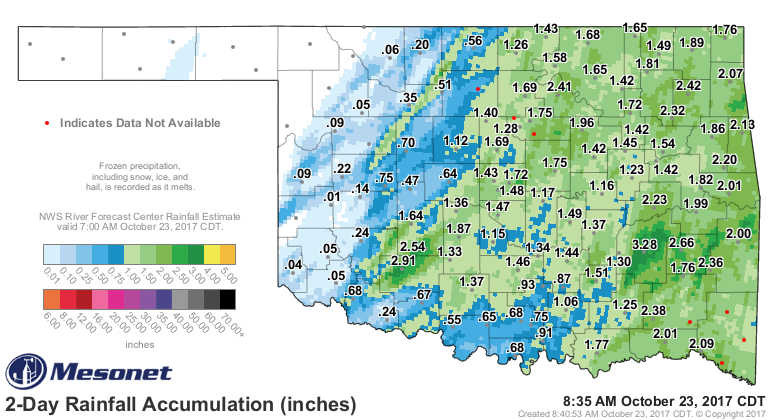
http://ticker.mesonet.org/archive/20171023/48hour-rain-totals.png
Well THAT was exciting, no? We knew the front was going to cool us down, bring
rain and a chance of severe weather. Who knew the Beach Boys would become the
Waterspout Boys, however (unless you've been living in a cave, I'm sure you
heard the Beach Boys concert at the Riverwind Casino west of Norman was
interrupted by a very unwelcome guest in the form of a tornado). Still no word
on the twister's intensity, but NWS personnel will no doubt have that info
shortly.
The good news was the mostly-statewide rain that fell with the storms, with
amounts ranging from 1-3 inches across a good portion of the southeastern two-
thirds of the state. Some a bit more, some a bit less, although the NW corner
went without.
Now we're in for a roller coaster ride typical of fall with fronts, warm ups
and some dreaded/welcomed (pick your poison) flirtations with freezing weather...
all this week!
Our NWS friends will help us out here:
http://ticker.mesonet.org/archive/20171023/nws-norman-temps.png
http://ticker.mesonet.org/archive/20171023/nws-norman-freeze.png
http://ticker.mesonet.org/archive/20171023/nws-norman-tue-front.png
Step right up and get your fall roller coaster tickets!
It's not like you have a choice.
Gary McManus
State Climatologist
Oklahoma Mesonet
Oklahoma Climatological Survey
(405) 325-2253
==================================================
The OCS/Mesonet Ticker
https://ticker.mesonet.org/
To subscribe or unsubscribe from the Ticker
or for questions about the Ticker or its content
Phone or Email the Ticker Manager at OCS
Phone: 405-325-2253 Email: ticker@mesonet.org
---------------------------------------------------
-C- Copyright 2024 Oklahoma Climatological Survey
===================================================
|


 Tweet
Tweet