MESONET TICKER ... MESONET TICKER ... MESONET TICKER ... MESONET TICKER ...
September 20, 2010 September 20, 2010 September 20, 2010 September 20, 2010
It's September!
Remember that one Ticker where I said something that made sense and it turns out
I was right for once? Yeah, me either, so I went and searched and actually found
an example. In this gem from August 24 (a topaz ...definitely not a diamond)
http://ticker.mesonet.org/select.php?mo=08&da=24&yr=2010
after we received a nice cool down following a long spate of hot weather, I
warned:
"So enjoy the cool weather for a few days. A word of warning to those wanting
to write an epitaph to summer with this latest cold front: that might be just
a tad premature. We're an upper-level ridge away from the heat again."
Now as much as I'd like to pat myself on the back right now (trust me, NOT a
good idea), I was correct due to climatology and our thirst for summer's end.
When we start yearning for cooler weather, we do try and hurry fall along but
our climate at times refuses to cooperate. So while there have been lots of
complaints about the heat sticking around, that's not exactly unexpected.
In actuality, we're not that far above normal for September thus far. On a
statewide basis, we're 2.3 degrees above normal for September 1-19 with an
average of 74.5 degrees. High temperatures are running 1.7 degrees above normal
at 86.8 degrees and the lows continue leading the way at 62.2 degrees, 2.9
degrees above normal. If September ended today, well that would be just weird.
However, if it DID end today, this September would not even rank as one of the
20-hottest since 1895.
The highest temperature from the Mesonet in September is 105 degrees at Beaver
on the fifth. The lowest reading of 43 degrees is from just a day earlier on the
fourth.
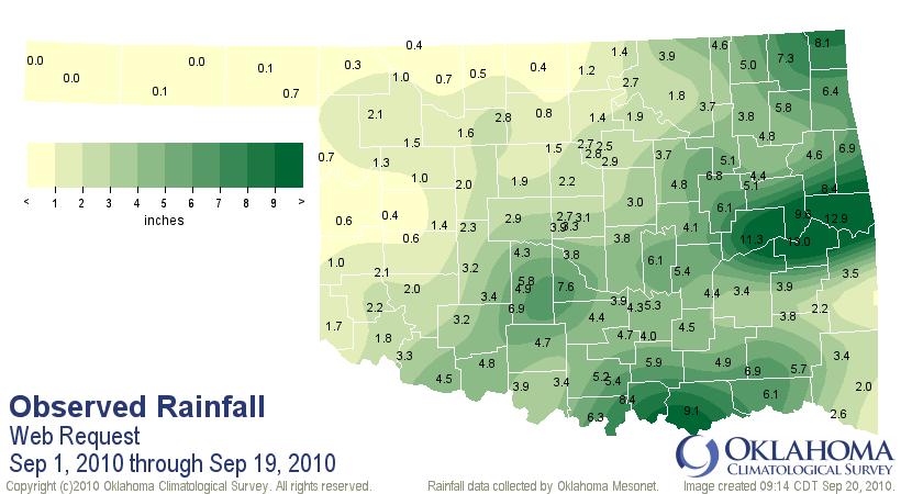
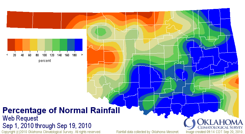
For precipitation, we owe a lot to the remnants of Hermine (not Earl...repeating,
not Earl!). As you can see, eastern Oklahoma has had some profound rainfall
for the month already owed mostly to that storm:
http://ticker.mesonet.org/archive/20100920/sept1-19tot.png
http://ticker.mesonet.org/archive/20100920/sep1-19pct.png
Stigler has had 12.96 inches for the month. Meanwhile, the northwest is once
again drying out with less than an inch for much of the Panhandle and its
periphery.
So a warm September, a tropical system bringing lots of rain to parts of the
state, three or four tornadoes ... how weird?
No, how September!
Gary McManus
Associate State Climatologist
Oklahoma Climatological Survey
(405) 325-2253
==================================================
The OCS/Mesonet Ticker
https://ticker.mesonet.org/
To subscribe or unsubscribe from the Ticker
or for questions about the Ticker or its content
Phone or Email the Ticker Manager at OCS
Phone: 405-325-2253 Email: ticker@mesonet.org
---------------------------------------------------
-C- Copyright 2024 Oklahoma Climatological Survey
===================================================
|


 Tweet
Tweet