MESONET TICKER ... MESONET TICKER ... MESONET TICKER ... MESONET TICKER ...
June 29, 2012 June 29, 2012 June 29, 2012 June 29, 2012
Turn your key, sir!
You know that point in "War Games" when the WOPR (that big computer they let
control our nation's nuclear arsenal) was simulating an attack on the U.S. by the
U.S.S.R. (remember them??) in hopes to make us launch a real counter-strike? A
failed attempt, as it turns out, but then the WOPR decides to try and get the
launch codes anyway and jubilation turns to despair as NORAD General Beringer
realizes they may have to do the same thing all over again. That's sort of how
I feel about covering drought and extreme heat for a second straight summer. I
really thought we had enough momentum through March to keep drought, and the
extreme heat, at bay this year. But time for some good news. The next couple of
months may look fairly nasty at this point, but there is still time for a
pattern change. And more importantly, we're not nearly as bad off as we were
last year.
Let's take a look at June's heat thus far. The extreme heat has really been
confined to the last week or so, at least on a widespread basis. We had highs
in the 60s and 70s as late as the 21st in some parts of the state. But, the last
week has really bumped up the statewide average. Still, at least for the first
28 days of June, the numbers pale in comparison.
-****-
2012 vs. 2011 June Statewide Temperature Averages (June 1-28)
High T Low T Avg T
2012 91.5 66.2 78.9
2011 96.6 70.2 82.3
Normal 88.0 64.9 76.5
2011-2012 +5.1 +4.0 +3.4
-***-
So this June is also going to finish quite a bit above normal ... 2.4 degrees
above the normal statewide average so far and that will increase a bit over today
and tomorrow. Last June finished at 83.6 degrees, the second warmest on record
behind 1953's 84.6 degrees. June 2012 has a chance to sneak into the top 10 with
a couple more really hot days, and will be our fifth June in a row to end up
significantly warmer than normal. Hopefully that's a trend we can see reverse
itself. I'm sure we all enjoyed the wet and mild June 2007's 74.9 degree average,
which was also the wettest June in Oklahoma since records began in 1895 (a
statewide average of 9.84 inches ... WOW!).
Looking further at the differences between last June and 2012's version, the
regional changes are astounding. Here are the differences for each of the nine
climate divisions in the state, first 28 days of June 2011 vs. the same period
in 2012. Not even close. Refer to the climate division map to match the regions.
-****-
June 1-28 Regional Differences, 2011-2012
Region High T Low T Avg T
Panhandle/NW 3.1 0.1 1.6
North Central 5.9 3.9 4.9
Northeast 2.9 4.1 3.5
West Central 7.4 5.1 6.3
Central 7.0 4.1 5.5
East Central 3.2 4.3 3.8
Southwest 8.4 5.5 7.0
South Central 5.4 4.9 5.1
Southeast 2.3 3.5 2.9
-***-
Yikes! It was hot last year. The average high temperature in west central and
southwestern Oklahoma was above 100 degrees (100.4 and 101.7 degrees,
respectively). So a huge difference. Fortunately, we're a bit better off this
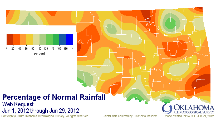
June on the precipitation side as well (statewide averages of 1.18 inches in 2011
vs. 2.53 inches in 2012). June 2011 was the fourth driest on record.
June 1-29, 2011: http://ticker.mesonet.org/archive/20120629/jun1-29_2011-pct.png
June 1-29, 2012: http://ticker.mesonet.org/archive/20120629/jun1-29_2012-pct.png
So we're not anywhere close to nuclear disaster level just yet. The statewide
average temperature over the last seven days was 84.6 degrees. If you look at
all the 7-day average temperatures across the state since records began, that's
only good for 1448th place. The top 7-day temperature in state history, you ask?
The August 8-14, 1936, average of 93.6 degrees. Tops for 2011? The Jul 31-Aug 6
average of 92.6 degrees, good for fifth place. Might as well throw the coldest
7-day average as well. That would be 6.8 degrees from December 19-25, 1989.
6.8 degrees??? NO THANKS!
How about a nice game of tic-tac-toe instead?
Gary McManus
Associate State Climatologist
Oklahoma Climatological Survey
(405) 325-2253
gmcmanus@mesonet.org
==================================================
The OCS/Mesonet Ticker
https://ticker.mesonet.org/
To subscribe or unsubscribe from the Ticker
or for questions about the Ticker or its content
Phone or Email the Ticker Manager at OCS
Phone: 405-325-2253 Email: ticker@mesonet.org
---------------------------------------------------
-C- Copyright 2024 Oklahoma Climatological Survey
===================================================
|


 Tweet
Tweet