MESONET TICKER ... MESONET TICKER ... MESONET TICKER ... MESONET TICKER ...
June 27, 2012 June 27, 2012 June 27, 2012 June 27, 2012
Welcome to the party, pal!
Quoting the great Officer John McClane of the New York City Police Department is
a great way to start a conversation. I only wish there was equally good prose
following it. But now much more of the country is getting a good dose of what
Oklahoma, Texas, New Mexico and Louisiana experienced last year. So welcome,
Kansas-Nebraska-Arkansas-Missouri-etc.-and so forth, to your OWN summer from
Hell.
Records will no doubt be shattered today somewhere. So the heat wave has set
in and the drought is worsening, not just here in Oklahoma but across much of
the interior of the U.S. Should it concern you?
Do you eat and/or produce food? If you answered "yes," then yes, you should be
concerned.
Word from the USDA shows how poorly things are getting.
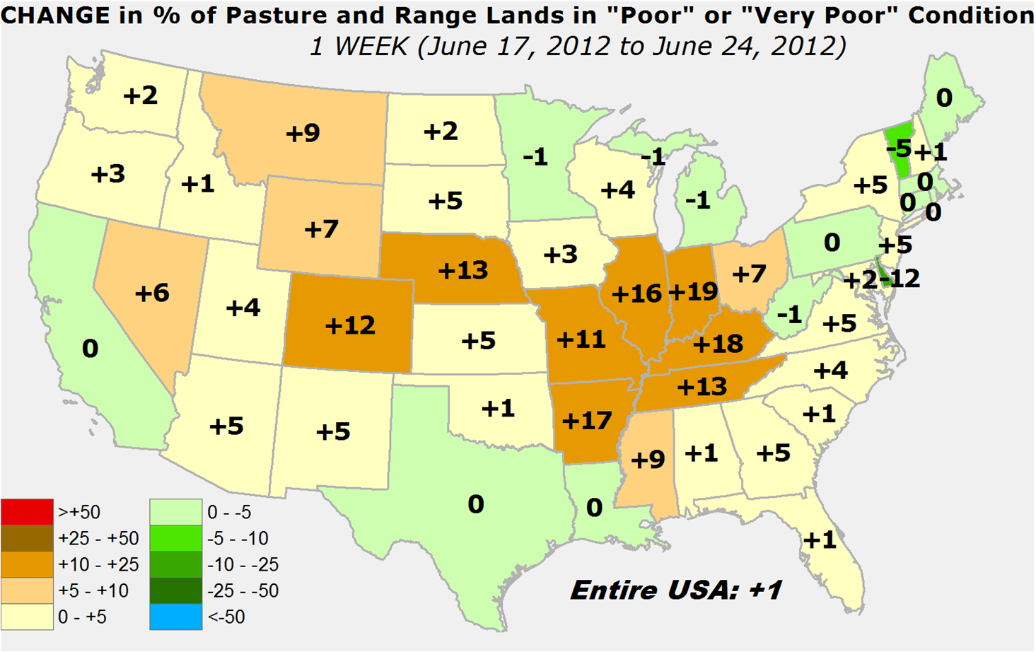
* Six percent of the country's pasture/rangeland dropped into the "poor/very poor"
category this week. That's the largest one-week expansion on record dating back
to 1996.
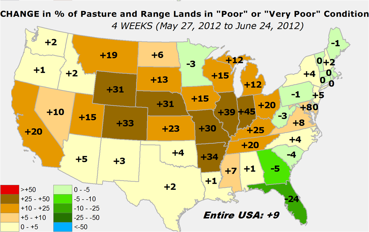
* The "poor/very poor" extent has expanded 12 percent in the last four weeks,
worst since a 13 percent decline ending in July 2001.
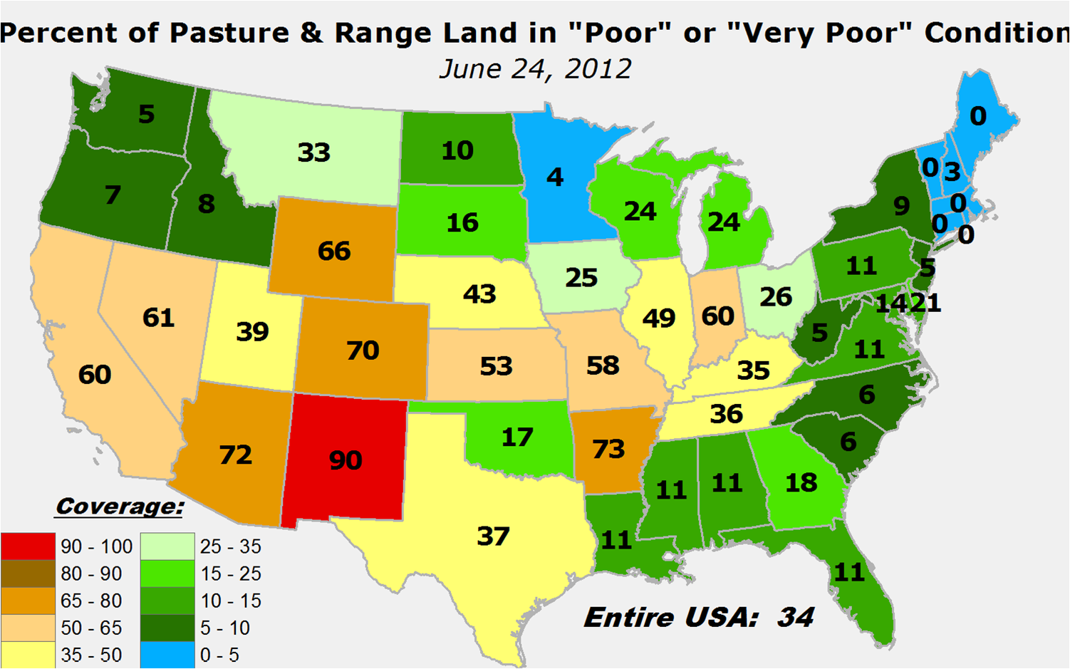
* 34 percent of the pastures/rangeland covering the U.S. are now in the "poor/very
poor" category. For the month of June, only June 30, 2002, had worse.
In other words, not only is it bad, it is particularly bad for June across much
of interior U.S. Let's take a look at some of that via some maps.
June 24 Pasture/Rangeland in "poor/very poor" condition
http://ticker.mesonet.org/archive/20120627/June24-pasture.rangeland.png
The good news locally is that Oklahoma is still in pretty good shape, at least
for now. All the states surrounding us, however, are not faring quite as well.
Things aren't horrible, except for maybe New Mexico, Colorado and Arkansas, but
it's the speed of deterioration under the "upper ridge of death" that is the
true concern, because it looks to stay around for awhile. Take a look at the
change in 1-week and 4-weeks.
1-week change
http://ticker.mesonet.org/archive/20120627/1week-change.png
4-week change
http://ticker.mesonet.org/archive/20120627/4week-change.png
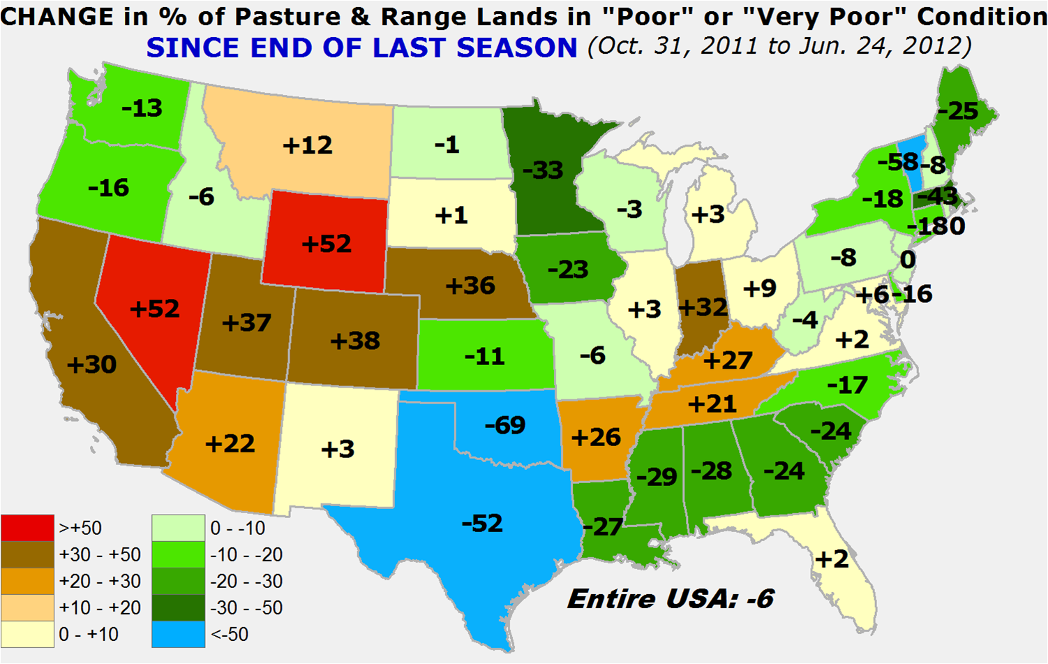
The improvement since last October in Oklahoma and Texas is quite evident,
thanks to the rains from October-April, mostly, with some spotty reinforcing
moisture in late May and early June.
http://ticker.mesonet.org/archive/20120627/change-since-October.png
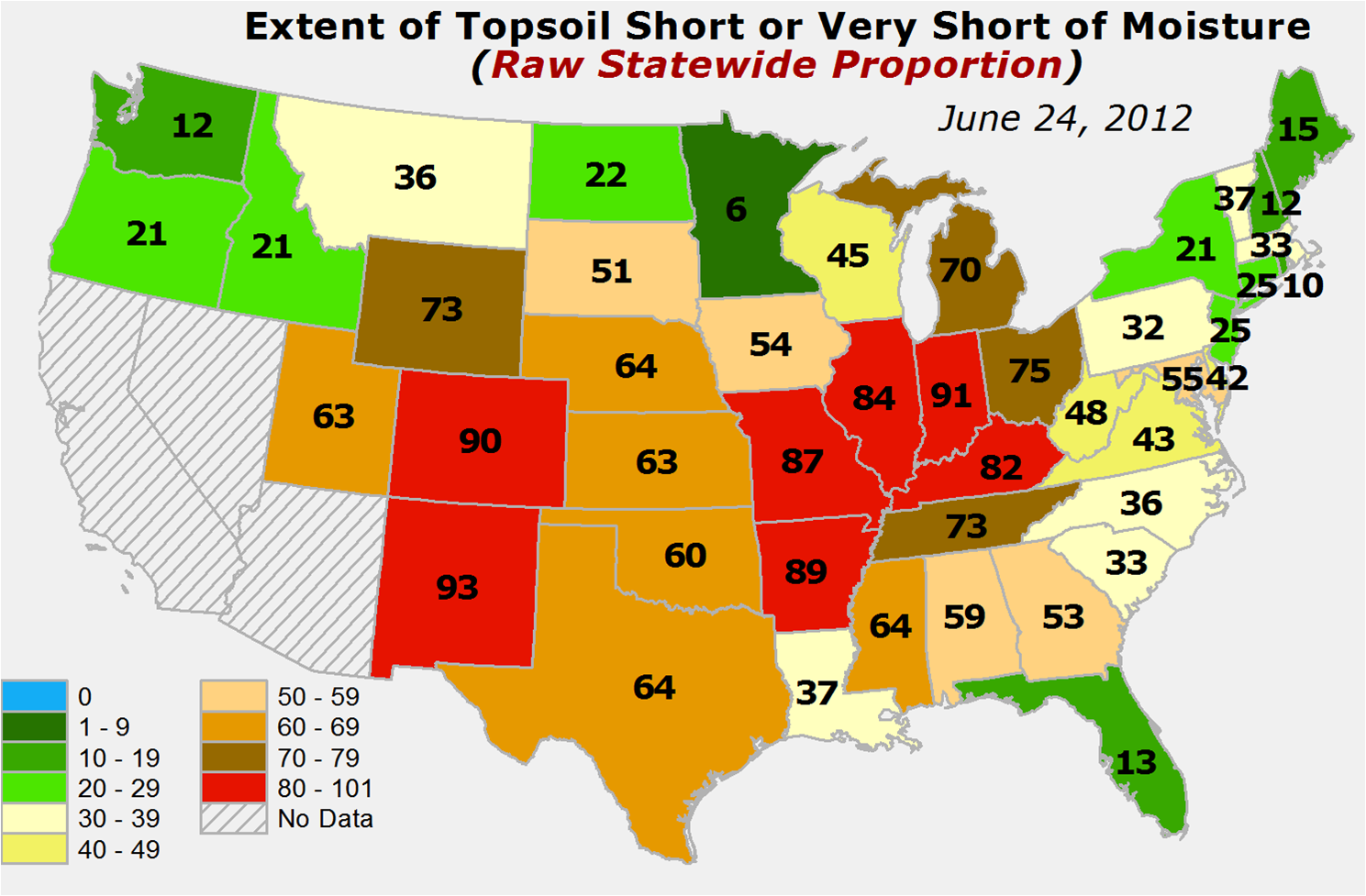
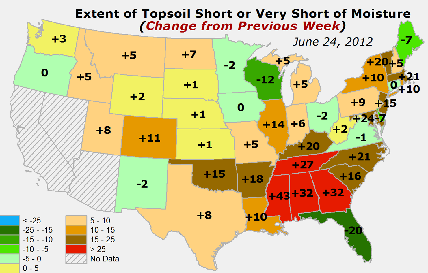
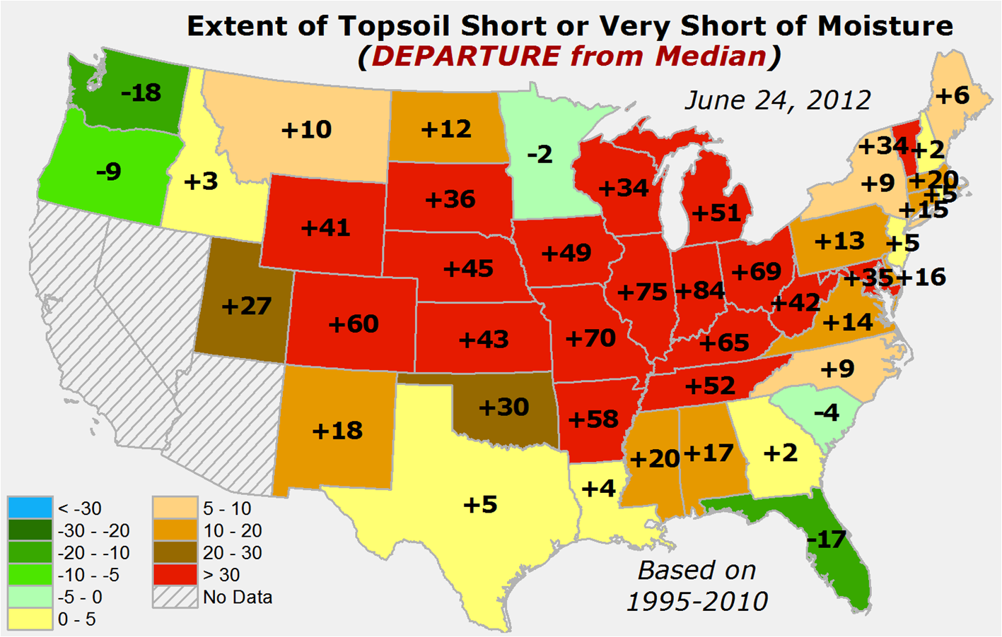
The news is not good for soil moisture as well, Oklahoma and Texas included
this time. Oklahoma's percentage of topsoils slipping into the short/very short
category rose 15 percent this week at 60 percent. Here are the maps.
June 24 extent of topsoils rated short/very short
http://ticker.mesonet.org/archive/20120627/june24-topsoil-extent.png
1-week change in extent
http://ticker.mesonet.org/archive/20120627/1-week-change-topsoils.png
Departure from median extent
http://ticker.mesonet.org/archive/20120627/departure-from-median.png
Temperatures up and down the Great Plains were in triple-digits yesterday and
headed that way today. Excessive heat watches and warnings and heat advisories
pepper the map throughout the central U.S. Oklahoma is almost entirely covered
by heat advisories.
http://ticker.mesonet.org/archive/20120627/national-advisories-map.png
--------------------------------------------------------------------------------
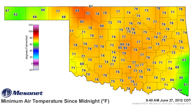
So watch again as the temperatures across our state approach record levels. Some
of them already broke records for warmest minimum temps for this date.
Mesonet minimum temperature map from this morning
http://ticker.mesonet.org/archive/20120627/today.TAIR.min.grad.png
84 degrees in Buffalo? The great place in the state...nay, the world, only got
down to 84 degrees last night? Okay, that's ugly. AND a record. Statewide record
for this data would be 93 degrees from Boswell in 1994. Not close to that.
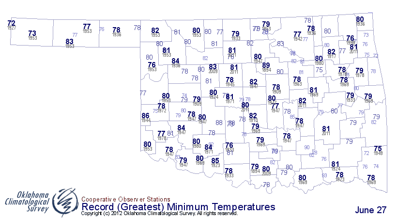
Record high minimum temps for June 27
http://ticker.mesonet.org/archive/20120627/june27.hitmin.png
I would assume Buffalo residents will be waiting awhile for their air
conditioners to cycle off.
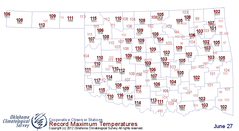
Here are today's high temperature records. And again, just in case, the
statewide record for today is 117 degrees from Mangum in 1980.
http://ticker.mesonet.org/archive/20120627/today.hitmax.png
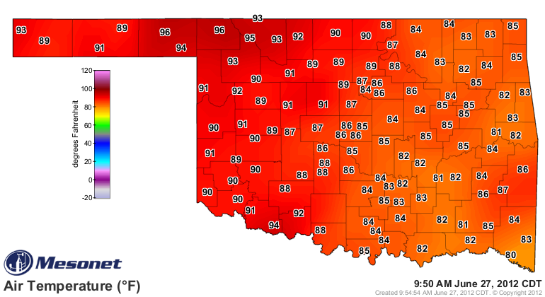
Oh by the way, it's 96 degrees in Buffalo and Beaver at 9:50am. Yuck.
http://ticker.mesonet.org/archive/20120627/current.TAIR.grad.png
Gary McManus
Associate State Climatologist
Oklahoma Climatological Survey
(405) 325-2253
gmcmanus@mesonet.org
==================================================
The OCS/Mesonet Ticker
https://ticker.mesonet.org/
To subscribe or unsubscribe from the Ticker
or for questions about the Ticker or its content
Phone or Email the Ticker Manager at OCS
Phone: 405-325-2253 Email: ticker@mesonet.org
---------------------------------------------------
-C- Copyright 2024 Oklahoma Climatological Survey
===================================================
|


 Tweet
Tweet