MESONET TICKER ... MESONET TICKER ... MESONET TICKER ... MESONET TICKER ...
June 25, 2019 June 25, 2019 June 25, 2019 June 25, 2019
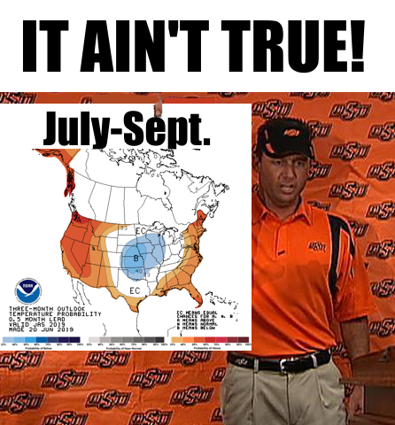
I'M AN OUTLOOK!
http://ticker.mesonet.org/archive/20190625/July-Sept-temp-outlook.png
I'm a man, and I *WISH* I was still 40. Anyway, Mike Gundy is 51 now, so he knows
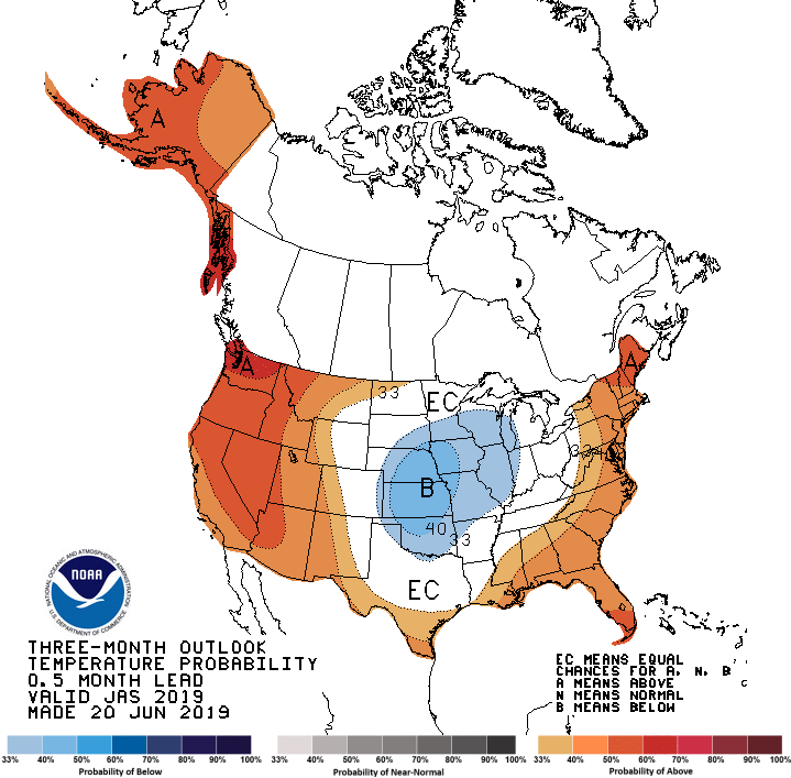
a lot more about climate outlooks than he did 11 years ago. The July-Sept.
temperature and precipitation outlooks from CPC last week snuck by us, but they
do beg a closer look. Here they are in their full glory for your examination.
http://ticker.mesonet.org/archive/20190625/July-Sept-temp-outlook.gif
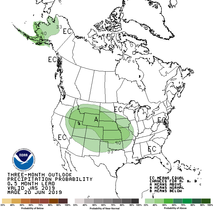
http://ticker.mesonet.org/archive/20190625/July-Sept-precip-outlook.gif
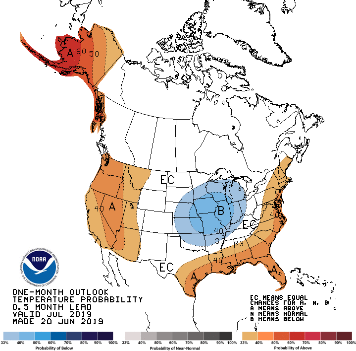
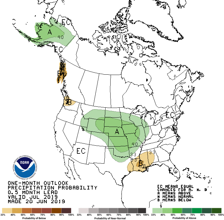
Much the same for the July outlooks.
http://ticker.mesonet.org/archive/20190625/July-temp-outlook.gif
http://ticker.mesonet.org/archive/20190625/July-precip-outlook.gif
At a glance, these look pretty darned reasonable to me. With all the rain we've
had this spring and early summer, our soils (and lakes) are filled to the brim
with moisture. That should mean more of the sun's energy will go towards
evaporating that excess moisture from the soils (evaporation = a cooling process)
instead of being absorbed by the surface and being re-emitted as sensible heat.
Add into that a precipitation outlook that sees increased odds of above normal
precipitation across Oklahoma (with higher odds across the northern fringe), and
that is another indication of below normal temperatures. Increased precipitation
and its associated cloudiness during the summer months are significantly
correlated with below normal temperatures in the Southern Plains. AND, there is
still a weak El Nino hanging around, so that also figures into the equation
just a bitt.
However, that temperature outlook tells us what the actual air temperature
could be like. It doesn't tell us what the APPARENT air temperature will be.
The apparent is the temperature equivalent perceived by humans, caused by the
combined effects of air temperature, relative humidity and wind speed. When the
sun comes out in its full summer glory, and the heat dome manages to build and
creep out way, we will see oppressive heat. Remember the spring and summer
of 2015? May 2015 was the wettest calendar month in OK history, June was the
33rd wettest (June) on record, and July was the sixth wettest on record. So
lots of rain straight through spring into summer. Most of that July rain came
during the first couple of weeks. The second half turned into full-time summer
with a visit from the heat dome, and the rest is pressure cooker history. Here's
a bit from our July wrap-up back in 2015:
"Although July's statewide average temperature was just a tad below normal at
81.4 degrees, the state still had plenty of hot, miserable weather. A large
area of high pressure camped over the state for much of the second half of the
month. That persistent summertime feature of the Southern Plains provided ample
sunshine and steered storms system up and around Oklahoma. Heat alerts were
fairly common during the second half of the month with heat index values of
105-115 across much of the state. Vinita captured both the number one and two
spot in the unbearable category with heat index readings of 118 degrees on the
24th and 116 degrees on the 19th. The 120 Mesonet stations registered a heat
index of at least 110 degrees 169 times during July."
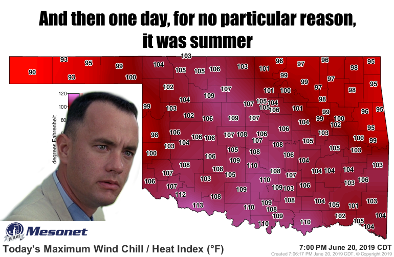
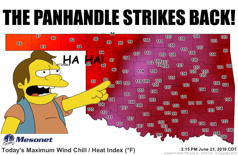
And let's not forget what we've already seen this June (if you don't recognize
these images, you really need to go like our Facebook and Twitter pages!).
http://ticker.mesonet.org/archive/20190625/June20-heat-index.png
http://ticker.mesonet.org/archive/20190625/June21-heat-index.png
So let's not get overconfident just yet. I expect a cooler than normal rest
of the summer, July through August. We'll see about September. So we need to
adjust our first graphic. Sorry Coach Gundy, it probably IS true, but not
entirely accurate.
But I also expect periods of unbearable heat. It's darned near inevitable.
Sometimes maybe just a day or two, other times a week or two. Heat indices into
the 110 degrees and higher range. The kind of oppressive conditions that make
those Alaska cruises look pretty darned nice.
As for me? Makes me want to puke.
Gary Gundy
Oklahoma State Climatologist
Oklahoma Mesonet
Oklahoma Climatological Survey
(405) 325-2253
gmcmanus@mesonet.org
==================================================
The OCS/Mesonet Ticker
https://ticker.mesonet.org/
To subscribe or unsubscribe from the Ticker
or for questions about the Ticker or its content
Phone or Email the Ticker Manager at OCS
Phone: 405-325-2253 Email: ticker@mesonet.org
---------------------------------------------------
-C- Copyright 2024 Oklahoma Climatological Survey
===================================================
|


 Tweet
Tweet