MESONET TICKER ... MESONET TICKER ... MESONET TICKER ... MESONET TICKER ...
June 21, 2010 June 21, 2010 June 21, 2010 June 21, 2010
Don't August My June
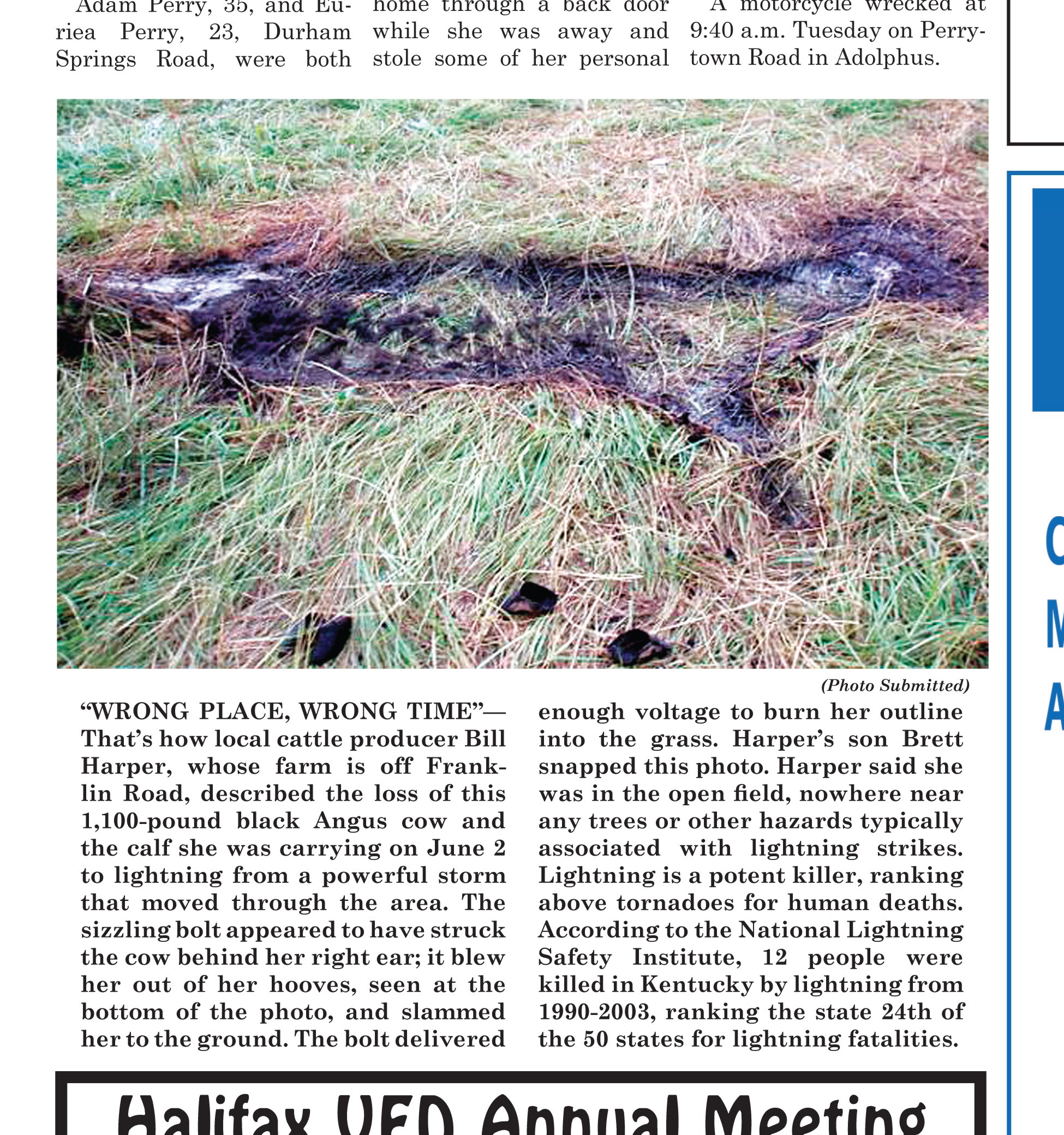
Before I begin to complain bitterly/bitterly complain about the heat, here's
something from the "it could always be worse" department:
http://ticker.mesonet.org/archive/20100621/Cow_vs._Lightning.jpg
And now, for a Ticker that will knock you off your hooves, sans lightning.
Yes, we have entered the summer doldrums, and yes, we have been there for most
of the month. Today's foray into astronomical summer is merely a formality. I
hate to crow (more of a robin fan, myself), but the climatological summer dates
(June 1-August 31) are a better fit this year. For the period June 1-June 20,
the statewide average temperature as measured by the Oklahoma Mesonet was 4.6
degrees above normal at 75.5 degrees. The average maximum temperature across
the state was 90.6 degrees, 3.7 degrees above normal. The average minimum was
5.7 degrees above normal at 69.7 degrees.
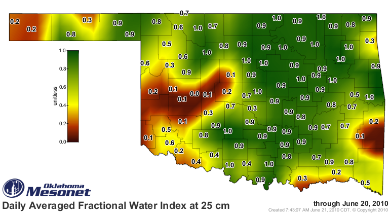
The "high" minimum temperatures are not a shock. The soil is still quite moist
across the state:
http://ticker.mesonet.org/archive/20100621/mesonet.FW25.grad.png
The drought area in the southwest and west central parts of the state shows up
quite well, doesn't it?
The sun is doing its work turning that soil moisture into atmospheric moisture.
Add to that a lovely subtropical ridge to the south and a trough of low
pressure to our west, both of which help to transport moisture from the Gulf
into Oklahoma, and you have delightful July-August weather in June.
What that moisture does is add to the heat stress on the people, animal, and
power supply of Oklahoma (hey to the power outages in my area over the last two
days!). Here's a look at the 10-highest dew points measured by the Mesonet
during June:
Antlers 6/13/2010 80.7
Broken Bow 6/6/2010 80.1
Sallisaw 6/19/2010 79.8
Wister 6/13/2010 79.4
Cloudy 6/6/2010 79.0
Vinita 6/19/2010 78.9
Inola 6/16/2010 78.7
Hectorville 6/19/2010 78.4
Ada 6/6/2010 78.4
Oilton 6/12/2010 78.4
Talk about your bad hair days (for those of us that only fondly remember bad
hair days, keep your whining to yourself!). The heat index, which is a
combination of the air temperature and humidity, has been in the danger zone as
well. Here are the top-10 Mesonet heat indices for June thus far (there have
been 47 heat indices above 105 degrees during this period):
Clayton 6/6/2010 107.6
Claremore 6/19/2010 107.5
Wilburton 6/6/2010 107.5
Blackwell 6/19/2010 107.5
Marshall 6/19/2010 107.3
Bixby 6/19/2010 107.1
Chickasha 6/19/2010 107.1
Burbank 6/19/2010 107.1
Vinita 6/19/2010 107.1
Altus 6/10/2010 107.1
During the same time period, there have only been 31 triple-digit maximum
temperatures measured across the state. Again, the top-10:
Hooker 6/10/2010 104.4
Mangum 6/5/2010 104.0
Altus 6/5/2010 103.4
Goodwell 6/10/2010 103.1
Tipton 6/5/2010 102.6
Hobart 6/5/2010 102.6
Hollis 6/5/2010 102.6
Fairview 6/5/2010 102.1
Bessie 6/5/2010 101.9
Grandfield 6/5/2010 101.9
With an important reminder of the moderating properties upon dry-bulb
temperatures that humidity can have, it's noted that all 31 of those
triple-digit temperatures have occurred in the western half of the state.
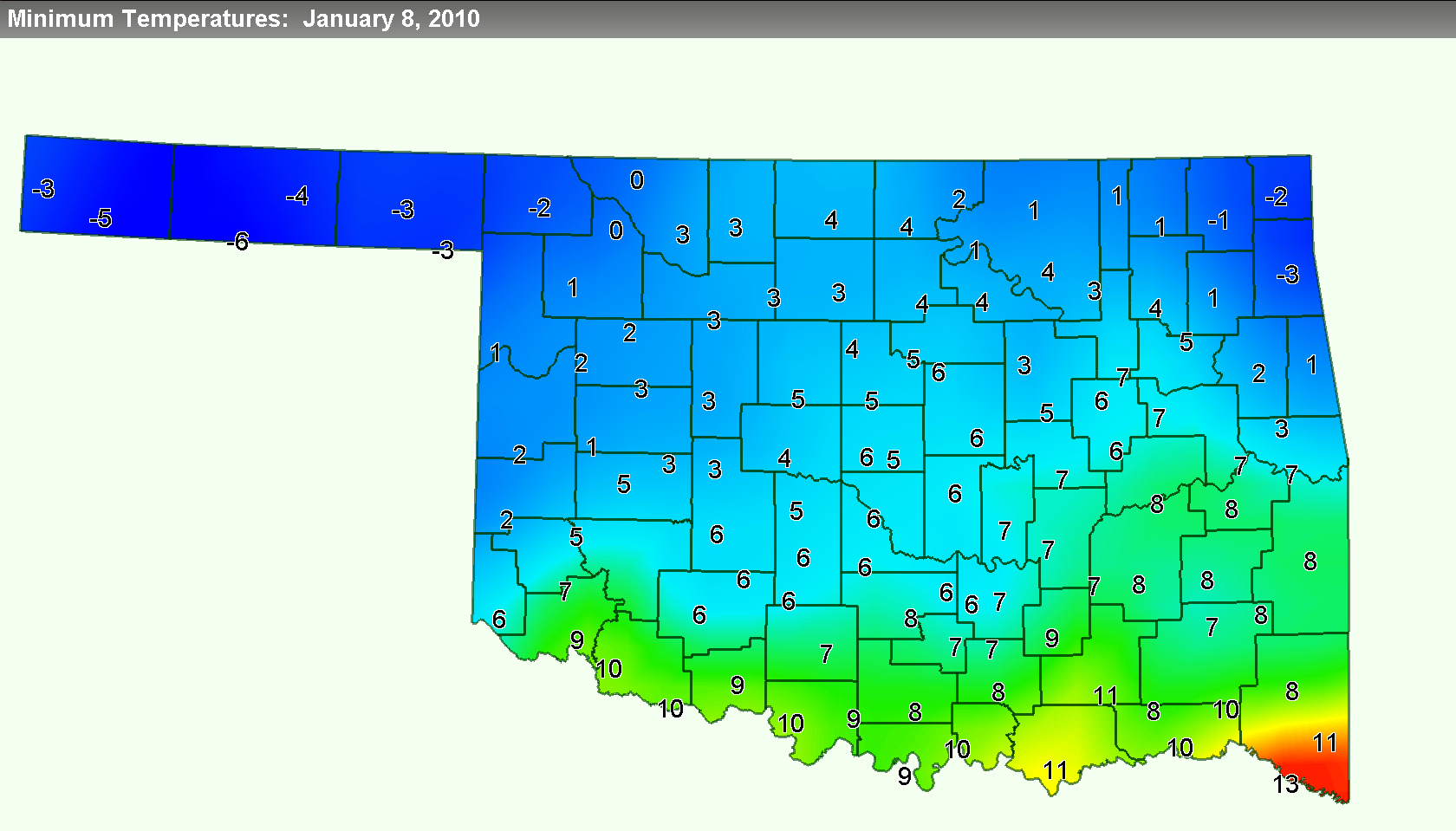
As a parting shot, here's a glance back at what we're missing from January 8,
2010 ... the low temperatures on the coldest day in Oklahoma (with a statewide
average temperature of 13.7 degrees)since December 2005. Enjoy.
http://ticker.mesonet.org/archive/20100621/jan10minimum_temps.png
Gary McManus
Associate State Climatologist
Oklahoma Climatological Survey
(405) 325-2253
gmcmanus@mesonet.org
==================================================
The OCS/Mesonet Ticker
https://ticker.mesonet.org/
To subscribe or unsubscribe from the Ticker
or for questions about the Ticker or its content
Phone or Email the Ticker Manager at OCS
Phone: 405-325-2253 Email: ticker@mesonet.org
---------------------------------------------------
-C- Copyright 2024 Oklahoma Climatological Survey
===================================================
|


 Tweet
Tweet