MESONET TICKER ... MESONET TICKER ... MESONET TICKER ... MESONET TICKER ...
June 19, 2014 June 19, 2014 June 19, 2014 June 19, 2014
Drought, on its way out?
I was trying to read this morning's new U.S. Drought Monitor report but I couldn't
really see it through all the heavy rain. Some would say that's a good problem
to have, but I will counter with I shouldn't be standing out in the rain with my
iPad (just kidding, colleagues at work ... I'm not that stupid. Or am I?? Always
keep them guessing.). Let's just get right to the report and see what improvements
have been made.
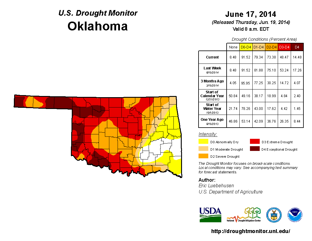
http://ticker.mesonet.org/archive/20140619/20140617_OK_trd.png
We didn't get a ton of rain before the Tuesday morning cutoff, but what we did
get helped make improvements in several areas of the state. Still looking good
over in far eastern Oklahoma, but we still have problems building across far
southern Oklahoma. The percentage of the state covered by D3-D4 drought dropped
from 53.24% to 48.47%, so good news there, and losing that strip of D4 in Ellis
County and down in Roger Mills and Beckham counties dropped the D4 amount alone
to 14.48%. The amount of the state without drought (D-Nada, or the white area,
and D0, which is technically not a drought category) rose to about 21% of the
state.
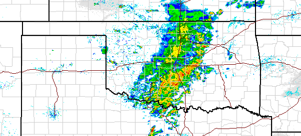
And yes Virginia, it is raining as we speak. Or write. Yet another one of those
systems that build up out west and then march through the state.
http://ticker.mesonet.org/archive/20140619/current-radar.png
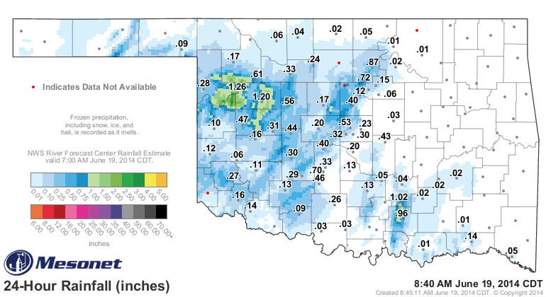
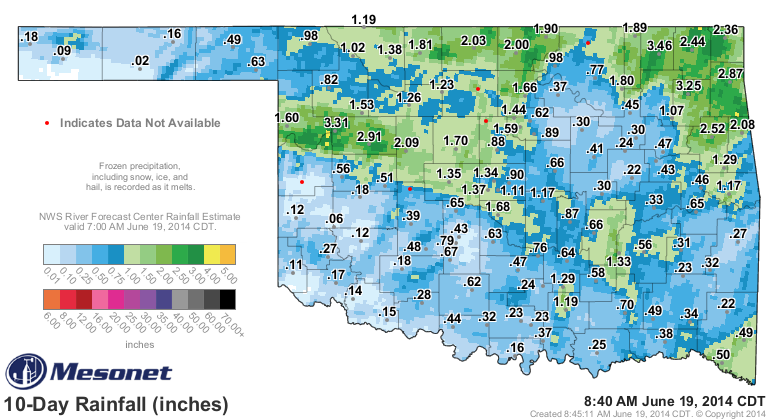
And that has given us some pretty decent totals to add onto what we've already
had in the last week or so.
http://ticker.mesonet.org/archive/20140619/24hour-totals.png
http://ticker.mesonet.org/archive/20140619/10day-totals.png
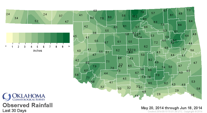
And if we go back to when all this moisture craze broke out, starting with some
showers in Beaver County thanks to that now legendary slow-moving upper-level
low pressure system way back on May 21, we can see that most of the state has
seen some darned good rains. But also notice that southern Oklahoma is now in
the danger zone (feel free to play some Kenny Loggins here ... kids, put down
the Super Nintendo and Sega and watch "Top Gun"). We'll just show you the 30-day
maps and stats here, which gives us an extra day.
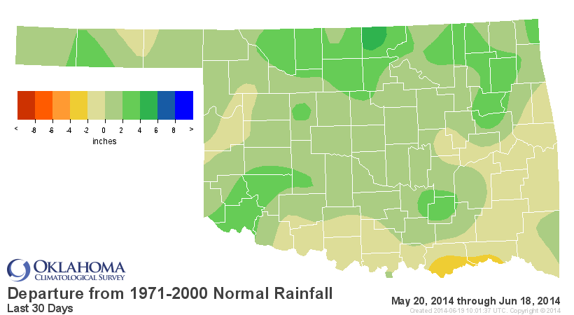
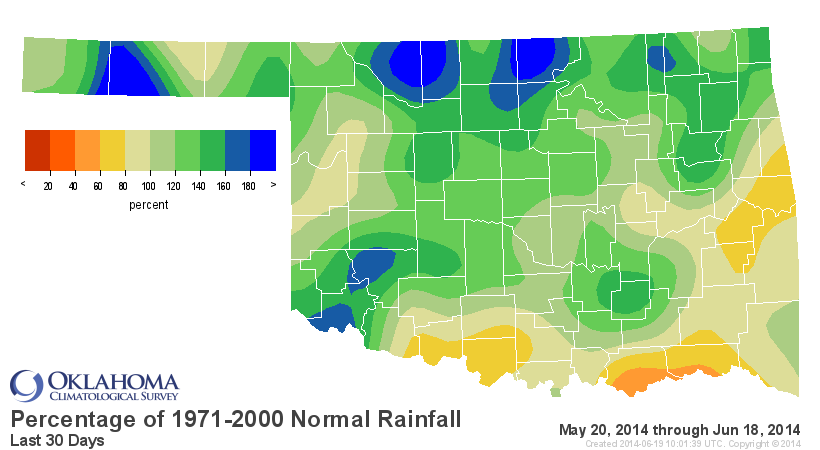
http://ticker.mesonet.org/archive/20140619/last30daystot.png
http://ticker.mesonet.org/archive/20140619/last30daysdel.png
http://ticker.mesonet.org/archive/20140619/last30dayspct.png
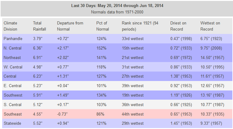
And here are the statistics.
http://ticker.mesonet.org/archive/20140619/last30days-stats.png
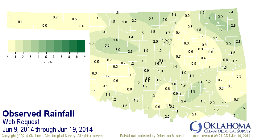
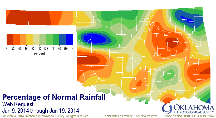
Hmmm, that's a bit odd. We've been running over an inch above normal statewide
since May 21 and had about the 16th wettest May 21-whatever date on record. As
it turns out, it's actually been a bit on the dry side over the last 10 days.
http://ticker.mesonet.org/archive/20140619/jun9-19.totals.png
http://ticker.mesonet.org/archive/20140619/june9-19.pct.normal.png
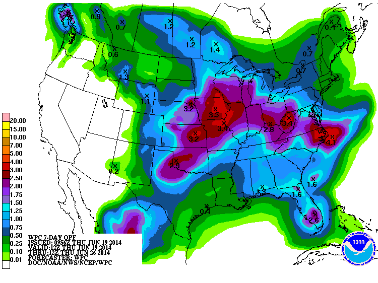
So here comes some more generous totals to the rescue (keep your fingers
crossed)! This 7-day forecast was released overnight, so some of the rain on
there has already fallen.
http://ticker.mesonet.org/archive/20140619/7day-rain-totals.gif
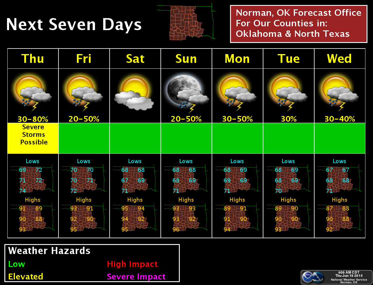
Here's a graphical look from the Norman NWS office on the storm chances over
the next 7 days, at least for their coverage area (but we'll use it as a general
guide for the state).
http://ticker.mesonet.org/archive/20140619/nws-norman-7day.planner.jpg
-------------------------------------------------------------------------------
CPC Outlooks
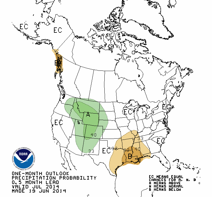
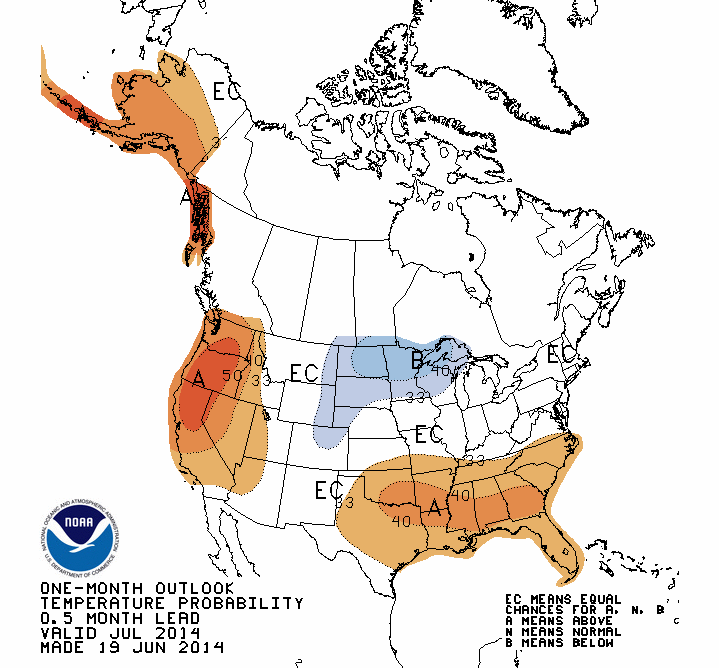
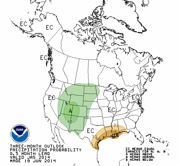
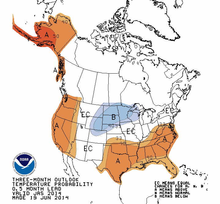
CPC released their July and July-September outlooks today. Not much there on
the precip side except for an increased change of below normal precip in SE OK
during July and above normal precip associated with the Desert Southwest monsoon
out in the far western Panhandle during the summer. However, both July and the
July-September outlooks have increased odds of above normal temperatures for
almost the entire state.
July Outlooks
http://ticker.mesonet.org/archive/20140619/july-precip-outlook.gif
http://ticker.mesonet.org/archive/20140619/july-temp-outlook.gif
July-September Outlooks
http://ticker.mesonet.org/archive/20140619/july-sept-precip-outlook.gif
http://ticker.mesonet.org/archive/20140619/july-sept-temp-outlook.gif
A not of caution, confidence is not generally too high in these outlooks during
the summer months. Perhaps a bit more for temperature than precip.
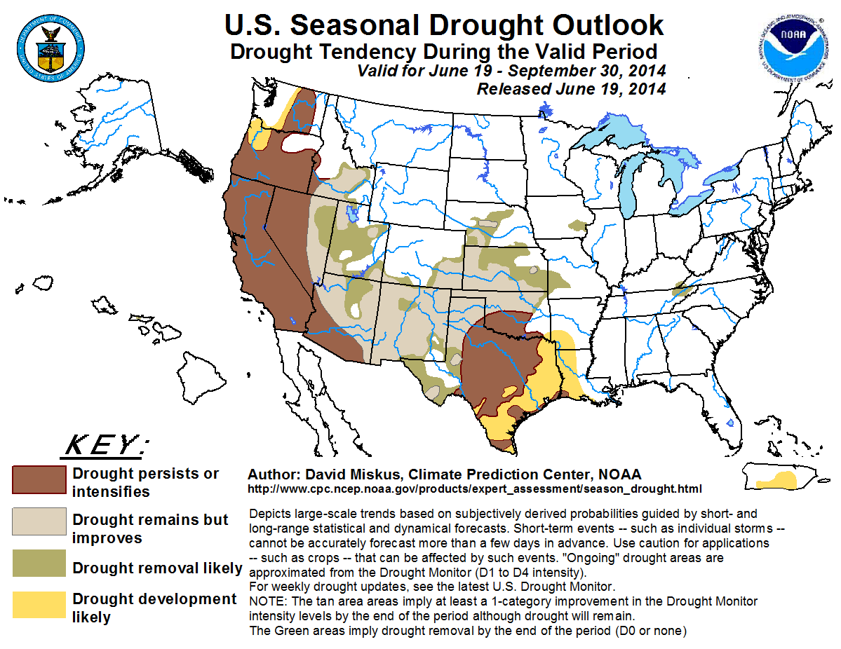
CPC also released their U.S. Seasonal Drought Outlook for the same period (ending
September 30, 2014) and it has good news for the northern half of the state.
http://ticker.mesonet.org/archive/20140619/season_drought.png
We see the "drought remains but improves" stamp across northern Oklahoma but
the "drought persists or intensifies" across southern Oklahoma. That would not
be good news for southern Oklahoma, where drought is currently intensifying for
the reasons mentioned earlier. It would get us to our secondary rainy season
in a bit better shape across the northern half of the state if it does indeed
work out the way the map intends.
And remember, El Nino is lurking. If we can get a strong El Nino to develop
and persist into the cool season, that usually tends to bring us above normal
moisture in the October-March'ish time frame.
Is drought on the way out? Too early to say, but there is hope!
Gary McManus
State Climatologist
Oklahoma Mesonet
Oklahoma Climatological Survey
(405) 325-2253
gmcmanus@mesonet.org
==================================================
The OCS/Mesonet Ticker
https://ticker.mesonet.org/
To subscribe or unsubscribe from the Ticker
or for questions about the Ticker or its content
Phone or Email the Ticker Manager at OCS
Phone: 405-325-2253 Email: ticker@mesonet.org
---------------------------------------------------
-C- Copyright 2024 Oklahoma Climatological Survey
===================================================
|


 Tweet
Tweet