MESONET TICKER ... MESONET TICKER ... MESONET TICKER ... MESONET TICKER ...
May 26, 2020 May 26, 2020 May 26, 2020 May 26, 2020
May-be we'll get lucky
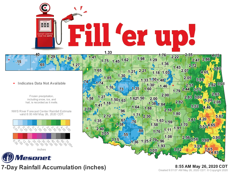
http://ticker.mesonet.org/archive/20200526/7day-rain-totals.png
Well that was interesting, and we dodged another May bullet. That week of
unsettled weather brought some severe weather, but let's face it, it could have
been worse. There were a few tornadoes, but it looks like they'll be rated in the
weak category. There was hail (of course, that's our MO this spring) and high
winds, but probably more flooding than anything. The totals above show a "nice"
77-county rain across the state. I use the term "nice" loosely, because as per
usual there was too much in eastern Oklahoma and not enough across the west. I'm
betting the far western Panhandle is less than happy today. And we still have
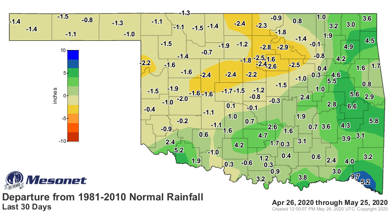
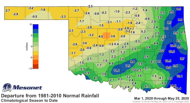
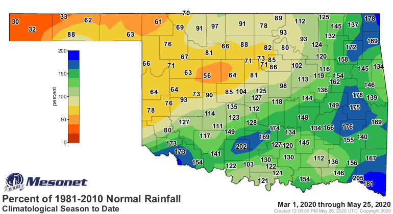
significant deficits across western into north central Oklahoma at several time
scales.
http://ticker.mesonet.org/archive/20200526/30days.norm_dep.png
http://ticker.mesonet.org/archive/20200526/30days.norm_pct.png
http://ticker.mesonet.org/archive/20200526/clim.norm_dep.png
http://ticker.mesonet.org/archive/20200526/clim.norm_pct.png
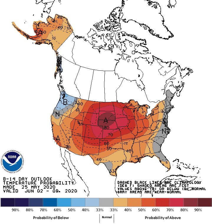
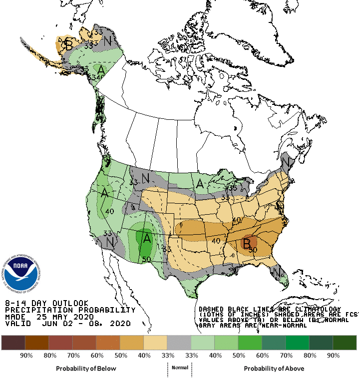
But I'll be darned if it doesn't look like we'll get out of May without a major
outbreak of tornadoes. I know the jinx effect I've had on trying to get warmer
weather in here and to stick around (obviously that isn't working), but there's
only a week left in the month and storm systems are looking pretty scarce over
that time. We have a few more days with rain chances then it looks like we'll
see an early preview of a summer ridge. Hard to call it a "death ridge," where
precip chances go to die, but it's close. Rain chances are already dwindling
rapidly across western Oklahoma ahead of the ridge's arrival, as the large
upper-level low that brought us our exciting weather pulls off to the northeast.
http://ticker.mesonet.org/archive/20200526/june2-8-temp-outlook.gif
http://ticker.mesonet.org/archive/20200526/june2-8-precip-outlook.gif
http://ticker.mesonet.org/archive/20200526/7day-rain-forecast.gif
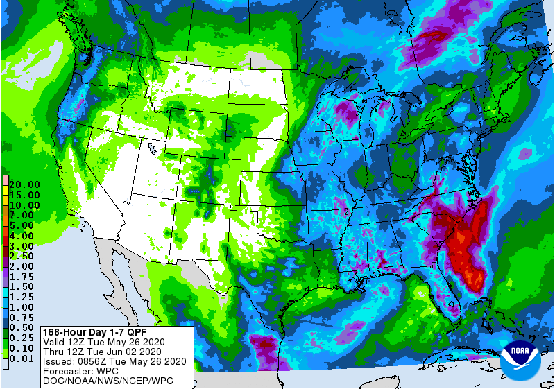
If we can get out of May with less than a dozen tornadoes, that's a win. But we
still need rain across western Oklahoma. June battles May for the wettest
month supremacy, so there's still time to beat the summer doldrums. For now,
however, we'll see a warm up through next week as rain chances start to
diminish.
Gary McManus
State Climatologist
Oklahoma Mesonet
Oklahoma Climatological Survey
(405) 325-2253
gmcmanus@mesonet.org
==================================================
The OCS/Mesonet Ticker
https://ticker.mesonet.org/
To subscribe or unsubscribe from the Ticker
or for questions about the Ticker or its content
Phone or Email the Ticker Manager at OCS
Phone: 405-325-2253 Email: ticker@mesonet.org
---------------------------------------------------
-C- Copyright 2024 Oklahoma Climatological Survey
===================================================
|


 Tweet
Tweet