MESONET TICKER ... MESONET TICKER ... MESONET TICKER ... MESONET TICKER ...
May 24, 2011 May 24, 2011 May 24, 2011 May 24, 2011
May 3, 1999?
This is very Weather-ish, but at least on the surface, today's setup for the
possible tornado outbreak looks different than what was occurring at 1:30 pm
on May 3, 1999. Today looks more juicy thus far! Of course, conditions
vertically also matter, but let's take a look at what's going on close to the
ground.
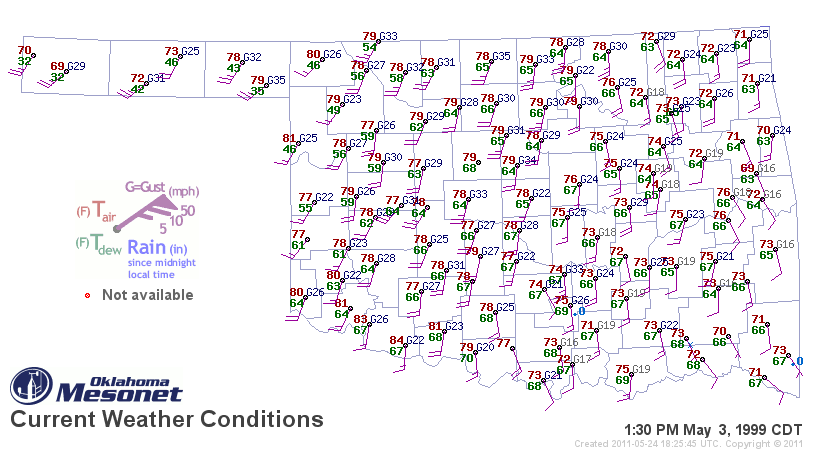
This Mesonet map is from May 3, 1999, at 1:30 pm.
http://ticker.mesonet.org/archive/20110524/may3-1999.png
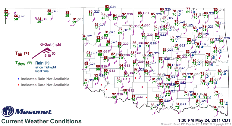
Here's a similar map for 1:30 pm today.
http://ticker.mesonet.org/archive/20110524/may24-2011.gif
May 3: Temperatures in the 70s, strong southerly winds gusting to 25-30 mph,
dewpoints in the mid-upper 60s.
Today: Temperatures in the 80s and 90s, strong southerly winds gusting to 25-35
mph, dewpoints in the lower 70s.
So surface wise, if you're looking at the ingredients to these nasty cake, we're
more well-stocked today.
YIKES!
Stay weather aware, and safe!
Gary McManus
Associate State Climatologist
Oklahoma Climatological Survey
(405) 325-2253
gmcmanus@mesonet.org
==================================================
The OCS/Mesonet Ticker
https://ticker.mesonet.org/
To subscribe or unsubscribe from the Ticker
or for questions about the Ticker or its content
Phone or Email the Ticker Manager at OCS
Phone: 405-325-2253 Email: ticker@mesonet.org
---------------------------------------------------
-C- Copyright 2024 Oklahoma Climatological Survey
===================================================
|


 Tweet
Tweet