MESONET TICKER ... MESONET TICKER ... MESONET TICKER ... MESONET TICKER ...
May 1, 2014 May 1, 2014 May 1, 2014 May 1, 2014
Drought, Severe Weather Steal Headlines in April
The proverbial April showers will not lead to May flowers this year as the month
ended desperately dry across much of Oklahoma. Widespread rains never
materialized, which allowed drought to once again make significant gains to the
east from the hardest hit areas across western Oklahoma. Severe weather made a
few brief appearances as well, although the month was still tame compared to some
recent Aprils. The preliminary count from the National Weather Service of four
tornadoes during April is actually well below the 1950-2013 average of 12, but
one of those occurrences led to a fatality. An EF2 twister struck the small town
of Quapaw on April 27, killing one person and injuring five others according to
the Oklahoma Department of Emergency Management. Nearly 50 homes and businesses
were damaged in the storm, including the town's fire station.
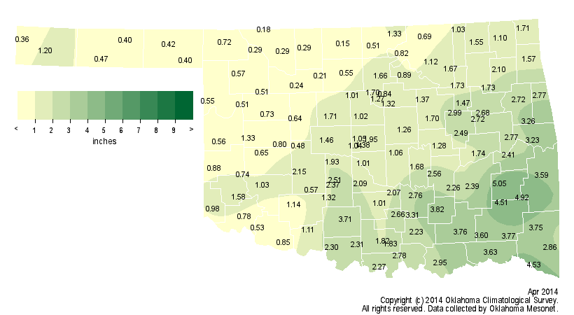
Preliminary data from the Oklahoma Mesonet indicate that the state experienced
its 12th driest April since records began in 1895 with a statewide average of
1.64 inches, a deficit of 1.72 inches. The month was particularly dry across
north central Oklahoma where an average of about a half-inch of moisture fell,
marking this April as the second driest on record for that region. Most Mesonet
sites across western and northern Oklahoma recorded less than an inch of
rainfall, with several seeing less than a quarter-inch. Medford had the lowest
total with a meager 0.15 inches, 3.1 inches below normal for that location. Of
the 120 Mesonet stations, 36 recorded less than an inch of rainfall for the
month. Wilburton led the state with 5.5 inches of rain.
http://ticker.mesonet.org/archive/20140501/apr.totrain.png
http://ticker.mesonet.org/archive/20140501/apr.departure.rain.png
http://ticker.mesonet.org/archive/20140501/apr.pctrain.png
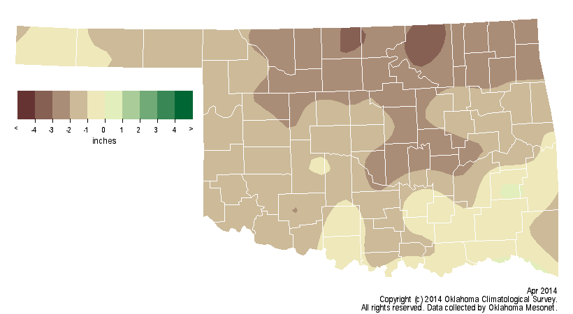
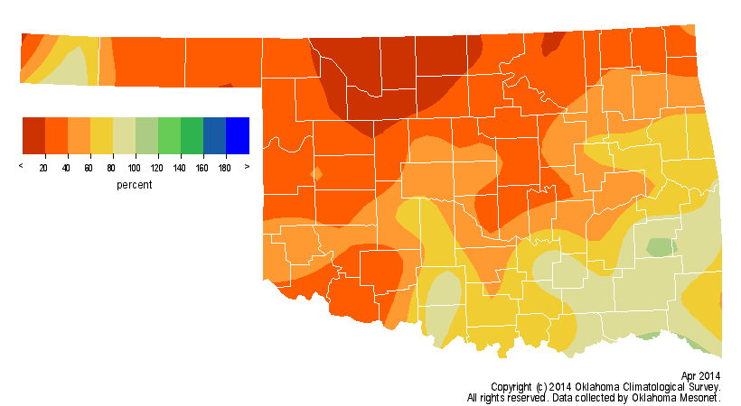
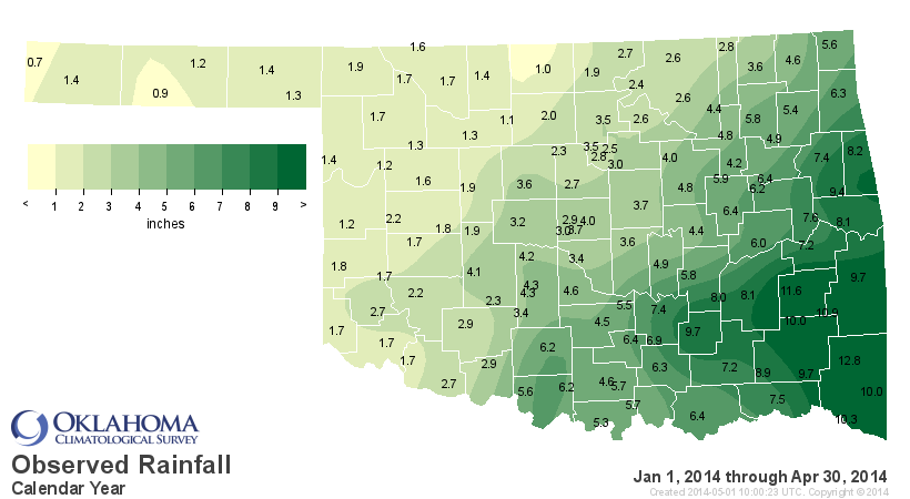
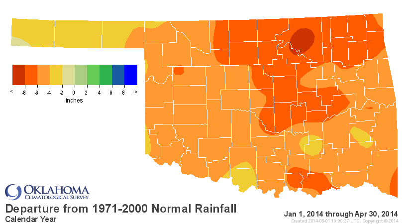
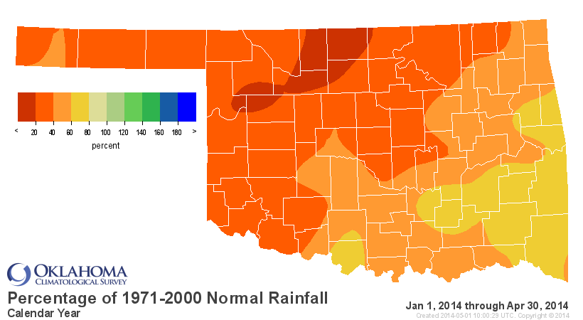
Dry weather has dominated headlines since the beginning of 2014. The January-
April statewide average was 4.20 inches, nearly 5.5 inches below normal and the
second driest such period on record. Medford has received a tally of an inch
since January 1, a deficit of over 8 inches and a crippling blow to one of the
state's most bountiful winter wheat producing areas. Only Goodwell and Kenton
recorded less for that period with 0.9 and 0.7 inches, respectively.
http://ticker.mesonet.org/archive/20140501/jan.apr.totals.png
http://ticker.mesonet.org/archive/20140501/jan.apr.departure.png
http://ticker.mesonet.org/archive/20140501/jan.apr.pct.png
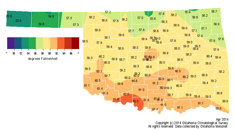
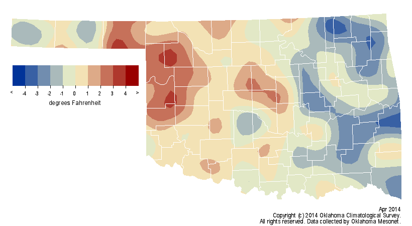
The statewide average temperature finished close to normal during April at 58.8
degrees, 0.3 degrees below normal.
http://ticker.mesonet.org/archive/20140501/apr.avgtavg.png
http://ticker.mesonet.org/archive/20140501/apr.departure.tavg.png
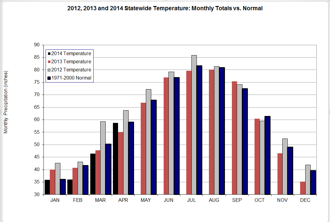
The first four months of the year were exceedingly cool, however, at 44.3
degrees statewide, 2.5 degrees below normal and the 16th coolest January-April
on record. April became the 13th month out of the last 15 to finish cooler than
normal.
http://ticker.mesonet.org/archive/20140501/2012-2014-temps.png
The state experienced a multitude of dry, windy days that saw massive dust
storms in the Panhandle that often pushed east into the main body of Oklahoma.
Those conditions also helped propel drought towards the northern and eastern
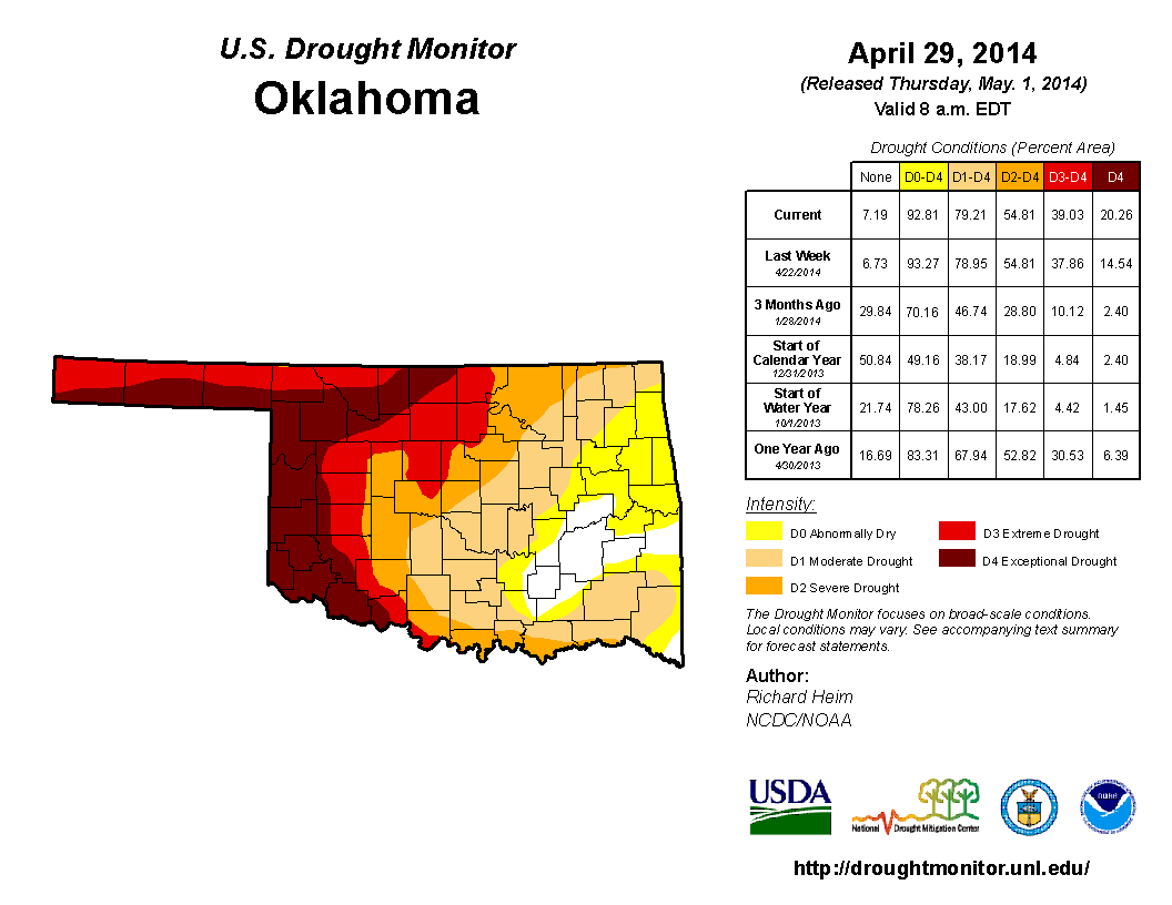
side of the state. The latest U.S. Drought Monitor report valid for April 29
showed over 20 percent of the state to be in exceptional drought and 39 percent
covered by at least extreme drought. Just over 79 percent of the state was
considered to be in at least moderate drought. The Drought Monitor?s intensity
scale slides from moderate-severe-extreme-exceptional, with exceptional being
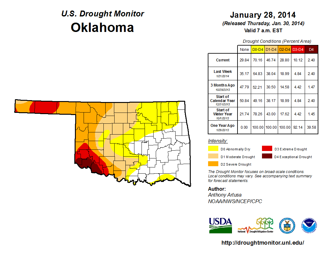
the worst classification. A mere three months ago only two percent of the state
was in exceptional drought, with 10 percent in at least extreme drought.
Currently, approximately 14 percent of the state is considered abnormally dry,
and seven percent completely free of any dry conditions. Most of those two
categories reside across southeastern Oklahoma.
http://ticker.mesonet.org/archive/20140501/20140429_OK_trd.png
http://ticker.mesonet.org/archive/20140501/20140128_ok_trd.png
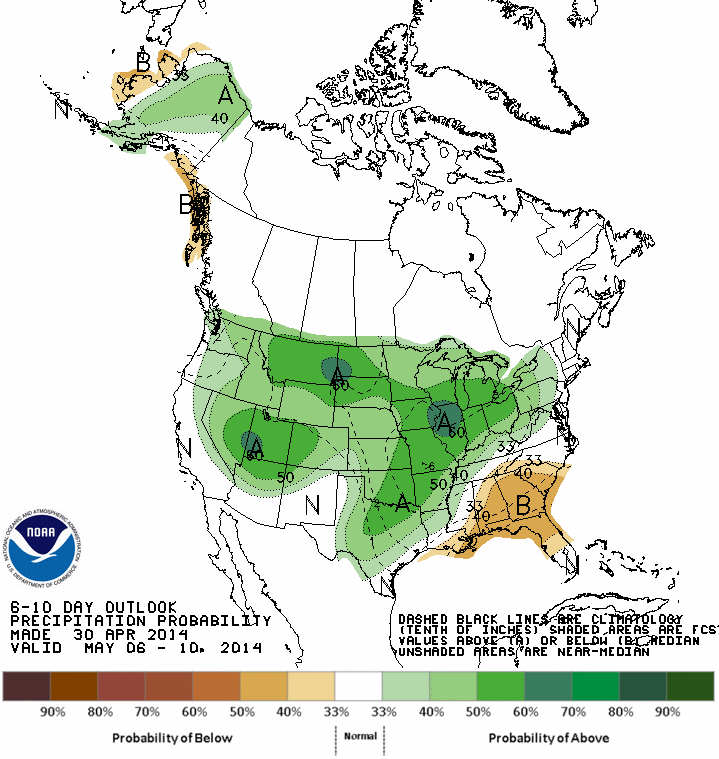
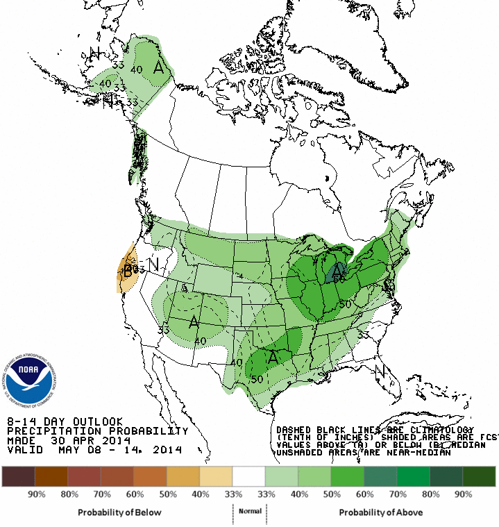
Moisture prospects for the first week of May look rather bleak, although there
are indications of more significant rainfall showing up for the month's second
week.
http://ticker.mesonet.org/archive/20140501/may6-10.precip.outlook.gif
http://ticker.mesonet.org/archive/20140501/may8-14.precip.outlook.gif
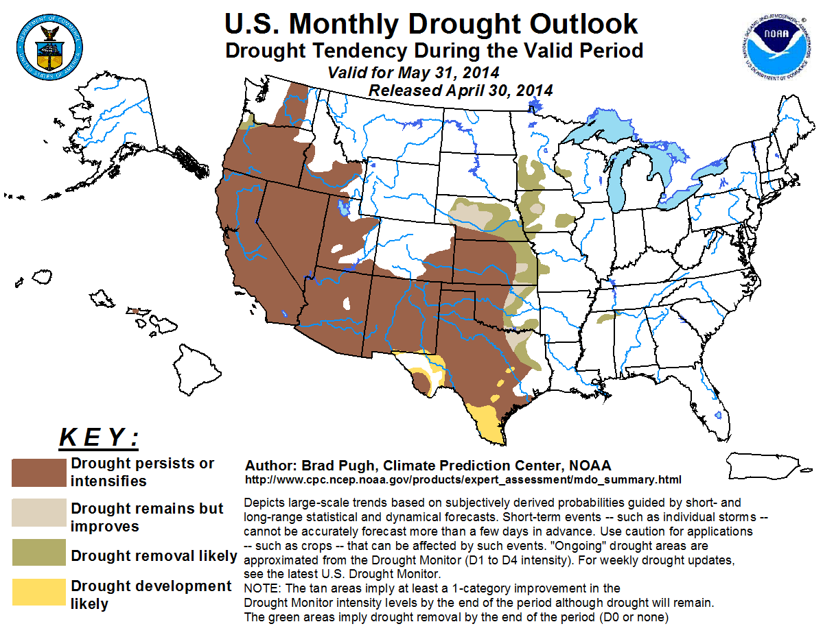
The Climate Prediction Center's (CPC) U.S. Drought Outlook for May expects the
western half of the state to see drought persist or intensify through the end
of the month with some improvements or removal possible across eastern
Oklahoma.
http://ticker.mesonet.org/archive/20140501/month_drought.png
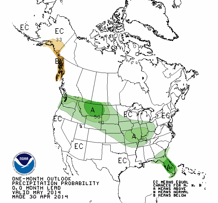
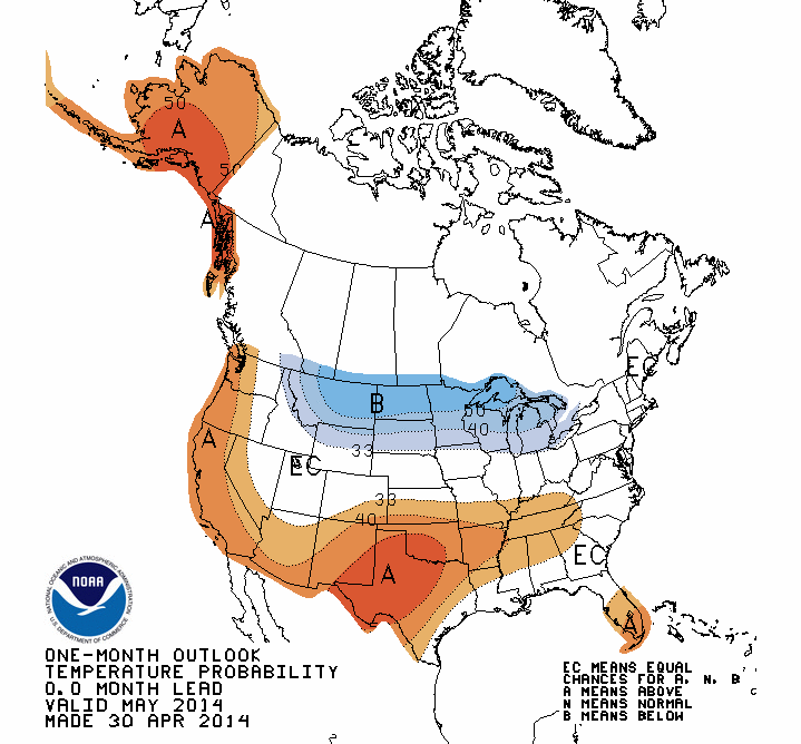
The CPC May outlook for temperature sees increased odds of above normal
temperatures, but no indication for rainfall with equal chances of seeing
above-, below- or near-normal amounts.
http://ticker.mesonet.org/archive/20140501/may.precip.outlook.gif
http://ticker.mesonet.org/archive/20140501/may.temp.outlook.gif
Gary McManus
State Climatologist
Oklahoma Mesonet
Oklahoma Climatological Survey
Work: (405) 325-2253
Cell: (405) 823-9054
gmcmanus@mesonet.org
==================================================
The OCS/Mesonet Ticker
https://ticker.mesonet.org/
To subscribe or unsubscribe from the Ticker
or for questions about the Ticker or its content
Phone or Email the Ticker Manager at OCS
Phone: 405-325-2253 Email: ticker@mesonet.org
---------------------------------------------------
-C- Copyright 2024 Oklahoma Climatological Survey
===================================================
|


 Tweet
Tweet