MESONET TICKER ... MESONET TICKER ... MESONET TICKER ... MESONET TICKER ...
February 8, 2018 February 8, 2018 February 8, 2018 February 8, 2018
Things are getting EXTREME
http://ticker.mesonet.org/archive/20180208/not.good.png
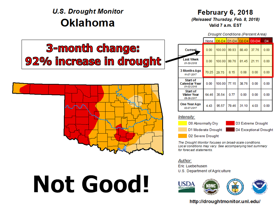
Yeah, not good to say the least. Here's a fresh map if you want to use it.
http://ticker.mesonet.org/archive/20180208/20180206_OK_trd.png
Extreme (D3) drought now covers 38% of Oklahoma, the third highest drought
category on the U.S. Drought Monitor. Exceptional (D4) drought is the highest
drought intensity. Virtually the entire state is in at least Moderate (D1) drought.
This is an increase from 8% three months ago. The state was last drought free on
Aug. 29, 2017. The state hasn't seen this much Extreme drought coverage since
April 14, 2015. That period is memorable for the flooding rains that soon
erupted during what was affectionately called the "Godzilla El Nino." And of
course 2015 went on to shatter the state's rainfall record, ending the horrible
drought of 2010-15.
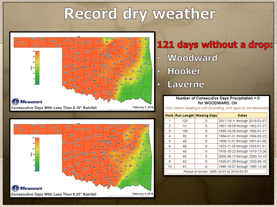
Just between you and me (and the tens of other people reading this), we were
DANGEROUSLY close to seeing Exceptional drought in the state. The statistics are
there already, at least on the 120-ish day time scale. So It's been 130 (131
counting today) since the far western Panhandle has seen at least a tenth of an
inch of rain in a single day, and up to 32 days across eastern Oklahoma. For a
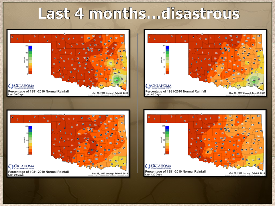
quarter-inch, we're looking even worse. And the percent of normal rainfall
maps from the last 30 all the way out to the last 120 days are downright
astonishing.
http://ticker.mesonet.org/archive/20180208/last.4.months.png
Those zeroes you see across the NW on the 120 day totals are ZEROES ACROSS THE
NORTHWEST ON THE 120 DAY TOTALS! If I could go bigger font, I would. Counting
today, places like Woodward, Hooker and Laverne have gone 121 straight days
with NO precipitation, breaking consecutive day records dating back to the
early 1900s.
http://ticker.mesonet.org/archive/20180208/record-dryness.png
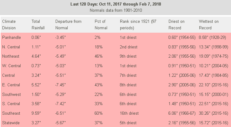
And from the statistical recap for each of Oklahoma's 9 climate divisions, as
well as looking based on the statewide average, we're in rare territory.
http://ticker.mesonet.org/archive/20180208/120day-rain-stats.png
It's the driest last 120 days on record for the Panhandle and west central
climate divisions, and the rankings don't get much better for other parts of
the state. What's striking, though, is what periods they're being compared to
on the dry side. In the "Driest on Record" column (and note that for those
ranked 1st, they should replace their counterparts), it's mostly 1950s...during
the worst drought on record for most of Oklahoma. And the two compared to
2005-06 hearken back to that horrible drought that brought arguably the state's
worst fire season to date.
Speaking of broken records, prospects for relief are still a tad on the
abysmal side. Yeah, there's some green showing up a bit farther west, but that's
for a hundredth of an inch or so. I don't think that's going to make up for
no rain in the last 4 months.
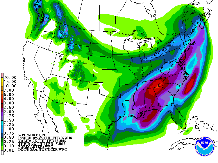
http://ticker.mesonet.org/archive/20180208/7day-precip-forecast.gif
We need a pattern change. We need to break down that blocking ridge of high
pressure on the West Coast and allow some storms (slow-moving, please) to drop
into the Desert Southwest and crank away, giving up some of those good
southerly winds with a nice fetch of moisture from the Gulf of Mexico. And THEN
let the storm move our way with plenty of water to work with. Is that showing
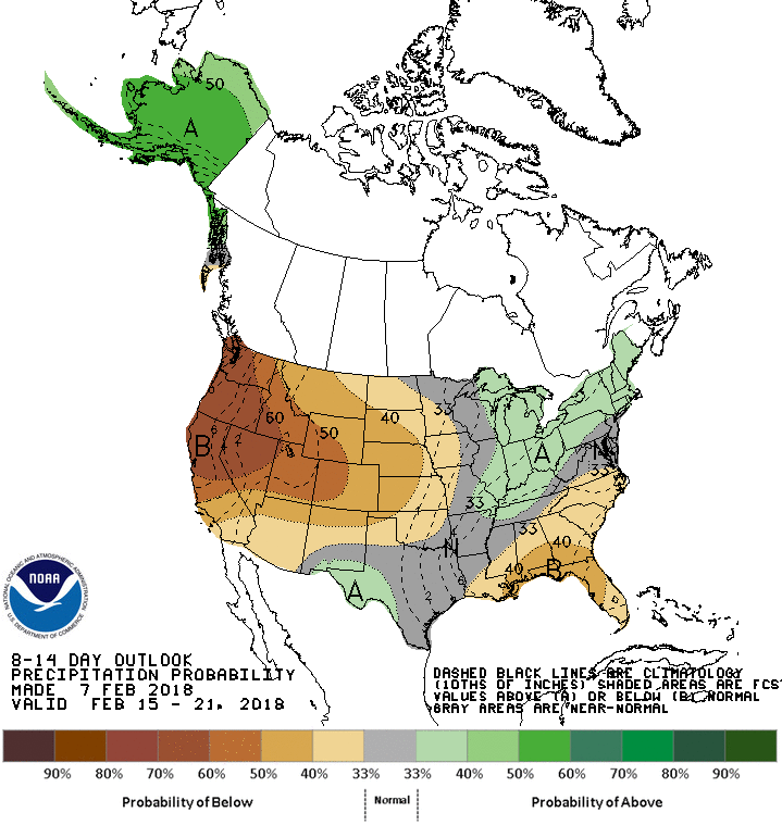
up yet? Not really. At least according to the 8-14 day outlook from CPC.
http://ticker.mesonet.org/archive/20180208/feb15-21-precip-outlook.gif
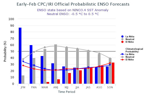
The good news (see, there's something at least!) is that the La Nina episode
we're currently in will start to die down as we get into spring. La Nina and
El Nino events almost always do when we approach the warm season. However, its
impacts, the tiling of odds towards warmer and drier than normal weather, still
have some momentum into spring. And, probably the worst part, it's set us back
quite a bit if we don't have a really nice spring.
http://ticker.mesonet.org/archive/20180208/ENSO-forecasts.png
So here's what we have in store for us. Wild roller coaster swings in
temperature with occasional fast-moving cold fronts. Sometimes they'll come
with a bit of weather (ice, snow, freezing rain, cold rain), sometimes not.
Usually nothing significant. But each storm system does bring wind, and
low humidity, and above normal temperatures out ahead of it. That means fire
danger, of course. And any delay in spring rains will extend that fire season
even longer.
The sun will come up tomorrow, as the song goes. But the rains, well, they're
staying mostly in the Plains. Just not the Southern Plains.
Gary McManus
State Climatologist
Oklahoma Mesonet
Oklahoma Climatological Survey
(405) 325-2253
gmcmanus@mesonet.org
==================================================
The OCS/Mesonet Ticker
https://ticker.mesonet.org/
To subscribe or unsubscribe from the Ticker
or for questions about the Ticker or its content
Phone or Email the Ticker Manager at OCS
Phone: 405-325-2253 Email: ticker@mesonet.org
---------------------------------------------------
-C- Copyright 2024 Oklahoma Climatological Survey
===================================================
|


 Tweet
Tweet