MESONET TICKER ... MESONET TICKER ... MESONET TICKER ... MESONET TICKER ...
February 1, 2013 February 1, 2013 February 1, 2013 February 1, 2013
Yes Virginia, there was a tornado in Oklahoma (first since October)
Climatologists are always the last to know these things. We're not allowed to
look at tornadoes. Our personalities and general outlooks on life don't allow
for that type of excitement. We will, however, be glad to look for trends in the
last 50 years. I don't know who this Virginia is, or why I'm answering her
question, but I'll proceed anyway.
The NWS folks in Tulsa completed the damage survey for the tornado that struck
so close to the Oklahoma-Arkansas border on January 29 and found that it did
indeed first touch down on the Oklahoma side of the line. Here is their Public
Information Statement with the, errrrr, info.
RATING: EF-2
ESTIMATED PEAK WIND: 110-120 MPH
PATH LENGTH /STATUTE/: 9 MILES
PATH WIDTH /MAXIMUM/: 700 YARDS
FATALITIES: 0
INJURIES: 0
START DATE: JANUARY 29 2013
START TIME: 255 PM CST
START LOCATION: 3.4 NE SHORT / SEQUOYAH COUNTY / OK
START LAT/LON: 35.605 / -94.498
END DATE: JANUARY 29 2013
END TIME: 304 PM CST
END LOCATION: 3.9 N NATURAL DAM / CRAWFORD COUNTY / AR
END LAT/LON: 35.704 / -94.394
SURVEY SUMMARY; THIS TORNADO DEVELOPED IN EXTREME NORTHEASTERN
SEQUOYAH COUNTY OKLAHOMA AND MOVED RAPIDLY NORTHEAST TO THE NORTH
OF NATURAL DAM ARKANSAS IN CRAWFORD COUNTY. IT MOVED THROUGH RURAL
AREAS OF BOTH COUNTIES SNAPPING AND UPROOTING MANY HARDWOOD AND
SOFTWOOD TREES IN THE PATH. THE MOST PRONOUNCED DAMAGE TO TREES
OCCURRED ON RAINWATER ROAD NORTHWEST OF UNIONTOWN IN CRAWFORD
COUNTY WHERE THE TORNADO TORE A PATH THROUGH THE WOODS OF MORE
THAN ONE THIRD OF A MILE WIDE. POWER POLES WERE SNAPPED AND A
HOUSE HAD MINOR DAMAGE WITHIN THE 9 MILE LONG PATH.
NOW THAT'S THE (whoops, why am I screaming?) ... now that's the first tornado
to touchdown in Oklahoma since an EF1 twister touched down 3 miles SW of
Healdton on October 13, 2012. That twister injured two people, but luckily
no fatalities. The January 29 tornado of this year is only the 17th confirmed
twister to touch down in the state during the year's first month.
I'm not sure if it will be rated EF2 for the time it was in Oklahoma, but it's
not going to surpass the 880 yards-wide F4 monster that struck Gans back on
January 22, 1957. That tornado killed 10 and injured 20.
------------------------------------------------------------------------------
Speaking of rain (sorta ... tough to get tornadoes without storms), our next
GOOD chance for GOOD rain appears to be about a week from now. The NWS' HPC
has basically painted the entire country some form of green in anticipation on
their 7-day forecast totals map. One of the few areas in the country not in the
green? The Oklahoma Panhandle, of course.
http://ticker.mesonet.org/archive/20130201/7day-rain.gif
Hopefully this will start to darken and heavier totals will start to show up
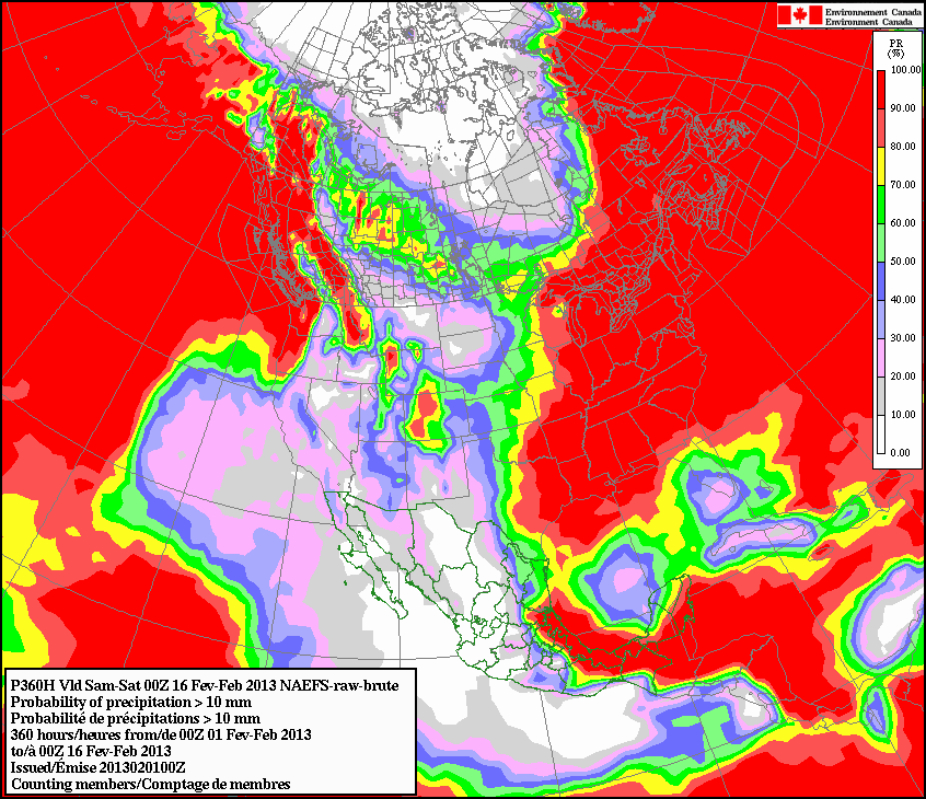
farther to the west. Our Canuck friends to the north give much of the state at
least a 20-30% chance to see accumulations of 0.4 inches of rain through next
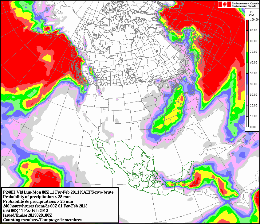
weekend. A smaller chance for accumulations of an inch. Along with their
back bacon and tuque, those hosers are also pretty good at predicting weather
across the North American Continent (I will admit from the start it's a sad
situation that all I know about Canada I learned watching Dave and Doug
McKenzie)
http://ticker.mesonet.org/archive/20130201/NAEFS-probs-4tenths.gif
http://ticker.mesonet.org/archive/20130201/NAEFS-probs-1inch.gif
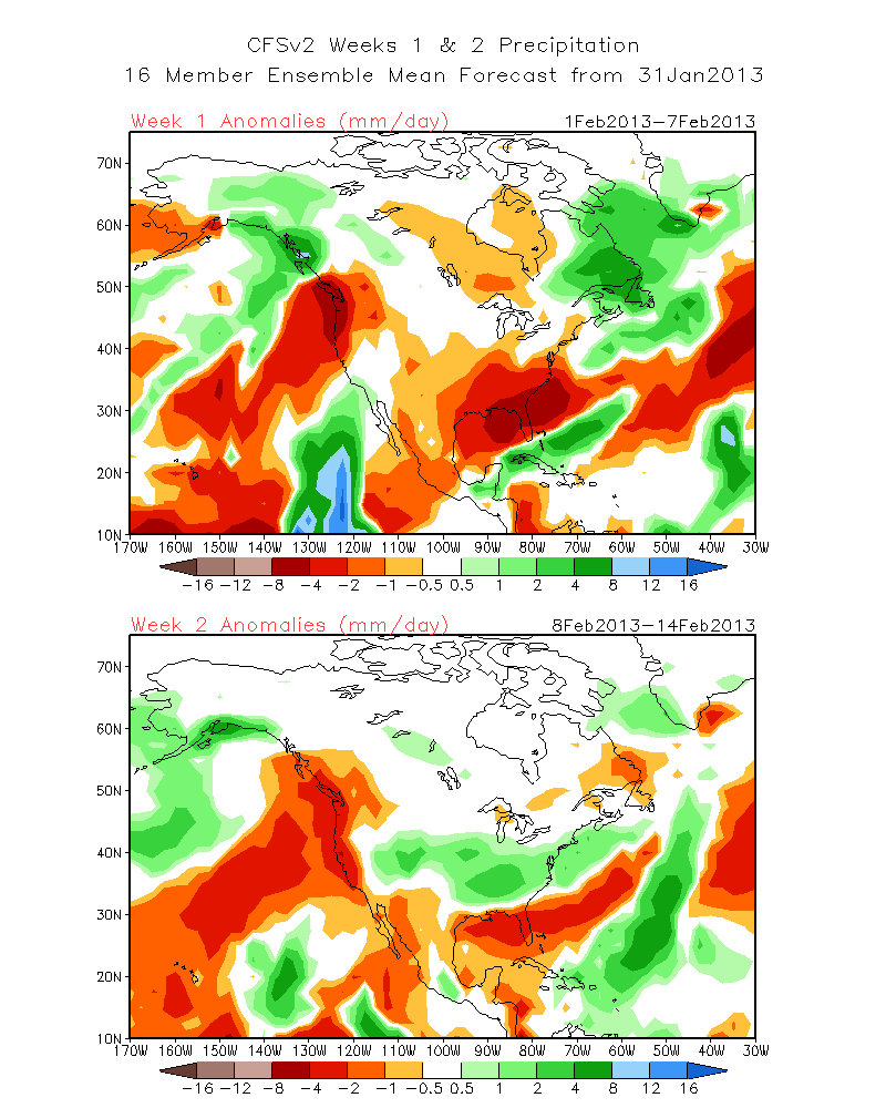
Our own CPC sees that rain as well in their second week mm/day forecast for
Feb. 8-14 (the lower panel).
http://ticker.mesonet.org/archive/20130201/CPC-week2.gif
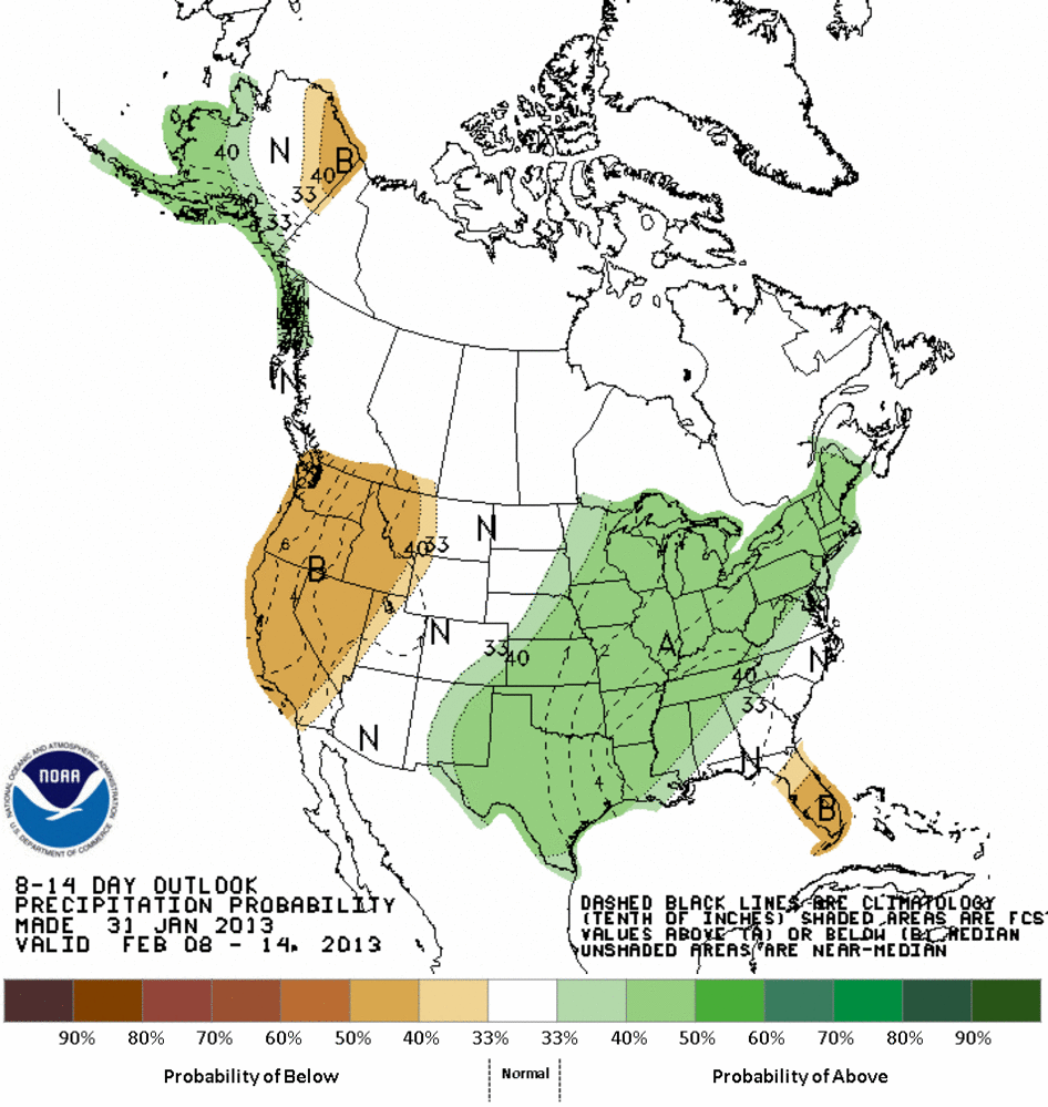
Which also shows up on their 8-14 day probability map for February 8-14 (eerie
how that worked out!).
http://ticker.mesonet.org/archive/20130201/814prcp.new.gif
So there you go. Hopefully we'll have reinforcements arriving next weekend.
That's the key. We don't want another 18-21 days between rainfall events.
Gary McManus
Associate State Climatologist
Oklahoma Climatological Survey
(405) 325-2253
gmcmanus@mesonet.org
==================================================
The OCS/Mesonet Ticker
https://ticker.mesonet.org/
To subscribe or unsubscribe from the Ticker
or for questions about the Ticker or its content
Phone or Email the Ticker Manager at OCS
Phone: 405-325-2253 Email: ticker@mesonet.org
---------------------------------------------------
-C- Copyright 2024 Oklahoma Climatological Survey
===================================================
|


 Tweet
Tweet