MESONET TICKER ... MESONET TICKER ... MESONET TICKER ... MESONET TICKER ...
January 3, 2012 January 3, 2012 January 3, 2012 January 3, 2012
December in review
A hearty welcome to 2012 from the entire Ticker staff, where our New Year's
resolution is 641 X 482 (you probably figured out long ago that we were a few
pixels away from normal). The first half of December continued Oklahoma's wet
ways that began in October. The statewide average precipitation total for the
month finished at 2.39 inches, which at 0.34 inches above normal doesn't seem
like a lot, but that's still good for the 27th wettest December since 1895.
http://ticker.mesonet.org/archive/20120103/dec-precip.png
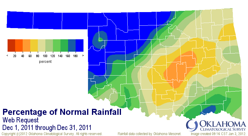
http://ticker.mesonet.org/archive/20120103/dec-pct-norm.png
As you can see, much of northwestern Oklahoma was well above normal thanks to
a couple of hefty precipitation events. Keep in mind that while the map shows
the Panhandle precipitation totals to at least 180 percent of normal, the actual
normal precipitation is generally less than an inch out that way. For instance,
Boise City's looking good at greater than 180 percent of normal, but it doesn't
seem so bountiful when you consider their normal for the month is about half of
an inch. But the 1.04 inches they did get was very much needed. For the entire
Panhandle, the average precipitation total was 1.77 inches, a whopping 1.1 inches
above normal or 263 percent of normal. Much the same for north central Oklahoma
with an average of 2.92 inches, 220 percent of normal with a surplus of 1.6
inches.
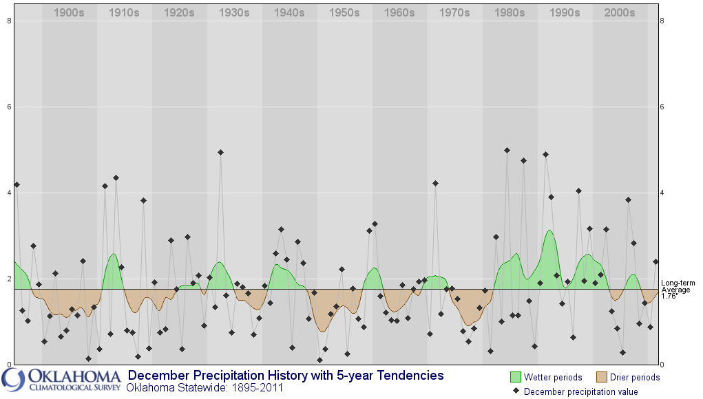
Another thing, how does 0.34 inches above normal get you the 27th wettest December
on record? Well, we've talked about this before, but without taking variability
and CHANGES in variability into context, assumptions can become dangerous. The
December climate trends graph for statewide average precipitation from 1895-2011
will demonstrate that better than words.
http://ticker.mesonet.org/archive/20120103/december-precip-trends.png
So now you can see the culprit. The December precipitation totals averaged
across the state spend a LOT of time on the extreme dry side, especially prior
to the 1980s ... another example of how our precipitation changed characteristics
30 years ago. Comparing this December's total to the normals established based
on the relatively wetter 1971-2000 data, the surplus doesn't seem significant.
Compared it to the long-term average of 1.76 inches, the surplus becomes 0.63
inches -- much more befitting of our 23rd wettest December on record. But again,
not that impressive compared to our recent past.
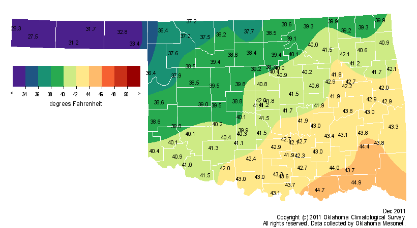
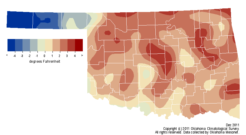
The statewide average temperature for the month was 40 degrees, a whole degree
above normal and the 52nd warmest December on record. One thing interesting
from the statistics though ... the Panhandle climate division was actually 2.8
degrees below normal at 32.2 degrees, the 25th coolest December for that area.
No doubt helped to that anomalous reading by the snowfall that pounded the area
mid-month.
http://ticker.mesonet.org/archive/20120103/dec-avg-temp.png
http://ticker.mesonet.org/archive/20120103/dec-temp-depart.png
The statewide statistic would obviously look a bit higher if not for the
Panhandle's overly cool month.
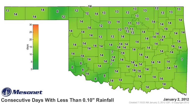
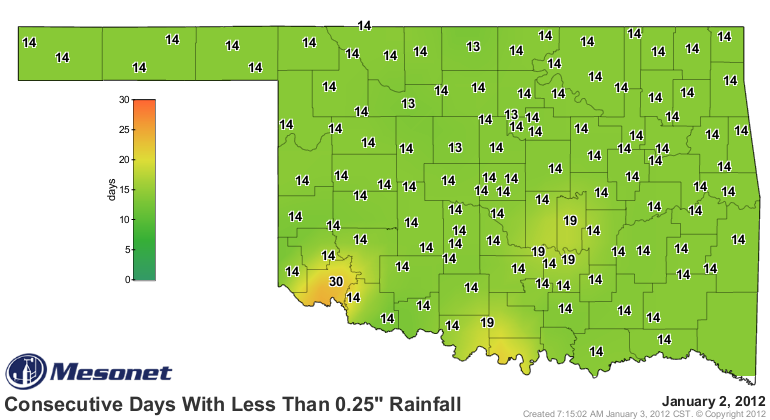
And don't look now, but it's been a couple of weeks since the state has seen
significant precipitation with little on the horizon.
http://ticker.mesonet.org/archive/20120103/mesonet.rainfall.tenthinch.png
http://ticker.mesonet.org/archive/20120103/mesonet.rainfall.quarterinch.png
Reason to panic? Hardly. While more of the wet stuff would be nice for further
drought eradication, a dry period from late December and into January is
nothing new. We are now smack dab in the middle of Oklahoma's driest time of
the year.
Last January was significantly dry as well, and look how that worked out for
us in February. Never count your chickens before they're frozen in a blizzard.
Gary McManus
Associate State Climatologist
Oklahoma Climatological Survey
(405) 325-2253
gmcmanus@mesonet.org
==================================================
The OCS/Mesonet Ticker
https://ticker.mesonet.org/
To subscribe or unsubscribe from the Ticker
or for questions about the Ticker or its content
Phone or Email the Ticker Manager at OCS
Phone: 405-325-2253 Email: ticker@mesonet.org
---------------------------------------------------
-C- Copyright 2024 Oklahoma Climatological Survey
===================================================
|


 Tweet
Tweet